Malkapur geodata
Malkapur (Maharashtra) is a populated place; located in India in Asia/Kolkata (GMT+5.5) time zone. With population of 32,000 people, there are 1357 cities with bigger population in this country. Compared to other cities in India, 74.1% of cities are located further ↑North; 88.5% of cities are located further →East and 87.1% of cities have lower elevation than Malkapur. Note1


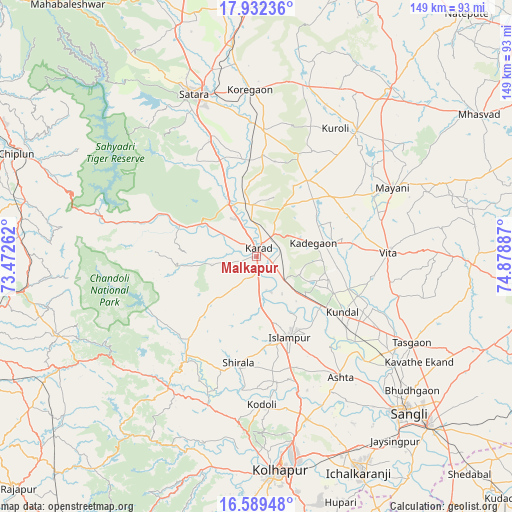
Malkapur GPS coordinates[2]
17° 15' 43.704" North, 74° 10' 32.664" East
| Map corner | latitude | longitude |
|---|---|---|
| Upper-left | 17.93236°, | 73.47262° |
| Center: | 17.26214°, | 74.17574° |
| Lower-right: | 16.58948°, | 74.87887° |
| Map W x H: | 149.3×149.3 km | = 92.8×92.8mi |
| max Lat: | 34.9274° ⇑74.1% North |
| Malkapur: | 17.26214° |
| min Lat: | ⇓25.9% South 8.09008° |
| min Long | Malkapur | max Long |
| 68.82655° | 74.17574° | 96.81° |
| W 11.5%⇐ | ⇒88.5% E |
Elevation
Elevation of Malkapur is 579 m = 1900 ft, and this is 283.4 m = 930 ft above average elevation for this country.
| Max E: |
3681 m = 12077 ft | 12.9% |
| Malkapur | 579 m 1900 ft | |
| Avg. | 295.6 m = 970 ft | |
Min E: |
1 m = 3 ft | 87.1% |
See also: India elevation on elevation.city.
Geographical zone
Malkapur is located in North Torrid zone (between Equator and Tropic of Cancer). Distance of this Northern Tropic circle is 686.5 km =426.6 mi to North.| Distance of | km | miles | from Malkapur |
|---|---|---|---|
| North Pole | 8087.7 | 5025.5 | to North |
| Arctic Circle | 5481.8 | 3406.2 | to North |
| Tropic Cancer | 686.5 | 426.6 | to North |
| Equator | 1919.4 | 1192.7 | to South |


Nearby cities:
15 places around Malkapur: (largest is in red/bold)
• Ashta
42.7 km =26.5 mi,  144°
144°
• Bhudgaon
59.9 km =37.2 mi,  131°
131°
• Jaisingpur
67.3 km =41.8 mi, 143°
• Karād
3.1 km =1.9 mi,  12°
12°
• Kodoli
42.9 km =26.7 mi,  177°
177°
• Kolhāpur
63.3 km =39.3 mi,  174°
174°
• Koynanagar
46 km =28.6 mi,  289°
289°
• Malkāpur
45.9 km =28.5 mi,  213°
213°
• Panhāla
50.5 km =31.4 mi,  187°
187°
• Pātan
31.7 km =19.7 mi, 293°
• Rahimatpur
36.8 km =22.9 mi,  3°
3°
• Satara
50.9 km =31.6 mi,  337°
337°
• Sāngli
61.3 km =38.1 mi, 137°
• Tāsgaon
51.7 km =32.1 mi,  118°
118°
• Vite
38.5 km =23.9 mi,  88°
88°
Sources, notices
• [Note1] Compared only with cities in India existing in our database
• [Src1] Map data: © OpenStreetMap contributors (CC-BY-SA)
• [Src2] Other city data from geonames.org with taken over terms of usage.
• [Src3] Geographical zone / Annual Mean Temperature by Robert A. Rohde @ Wikipedia
