Malkāpur geodata
Malkāpur (Maharashtra) is a populated place; located in India in Asia/Kolkata (GMT+5.5) time zone. With population of 13,343 people, there are 2623 cities with bigger population in this country. Compared to other cities in India, 75% of cities are located further ↑North; 90% of cities are located further →East and 86.9% of cities have lower elevation than Malkāpur. Note1


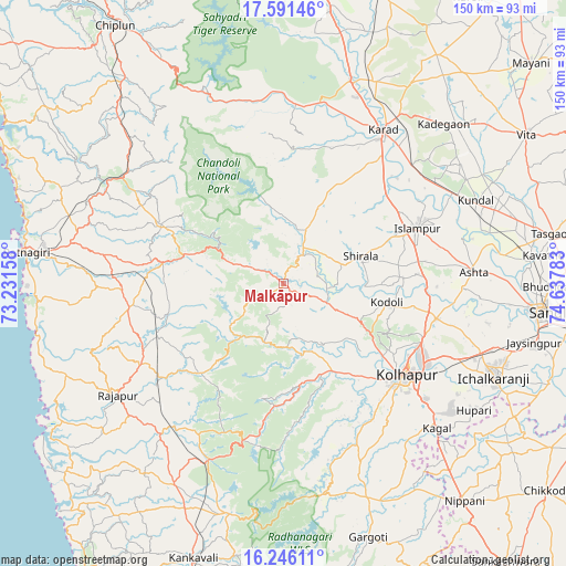
Malkāpur GPS coordinates[2]
16° 55' 11.964" North, 73° 56' 4.92" East
| Map corner | latitude | longitude |
|---|---|---|
| Upper-left | 17.59146°, | 73.23158° |
| Center: | 16.91999°, | 73.9347° |
| Lower-right: | 16.24611°, | 74.63783° |
| Map W x H: | 149.6×149.6 km | = 93×93mi |
| max Lat: | 34.9274° ⇑75% North |
| Malkāpur: | 16.91999° |
| min Lat: | ⇓25% South 8.09008° |
| min Long | Malkāpur | max Long |
| 68.82655° | 73.9347° | 96.81° |
| W 10%⇐ | ⇒90% E |
Elevation
Elevation of Malkāpur is 576 m = 1890 ft, and this is 280.4 m = 920 ft above average elevation for this country.
| Max E: |
3681 m = 12077 ft | 13.1% |
| Malkāpur | 576 m 1890 ft | |
| Avg. | 295.6 m = 970 ft | |
Min E: |
1 m = 3 ft | 86.9% |
See also: India elevation on elevation.city.
Geographical zone
Malkāpur is located in North Torrid zone (between Equator and Tropic of Cancer). Distance of this Northern Tropic circle is 724.6 km =450.2 mi to North.| Distance of | km | miles | from Malkāpur |
|---|---|---|---|
| North Pole | 8125.7 | 5049.1 | to North |
| Arctic Circle | 5519.8 | 3429.8 | to North |
| Tropic Cancer | 724.6 | 450.2 | to North |
| Equator | 1881.3 | 1169 | to South |


Nearby cities:
15 places around Malkāpur: (largest is in red/bold)
• Ashta
50.6 km =31.4 mi,  86°
86°
• Ichalkaranji
61.5 km =38.2 mi,  114°
114°
• Karād
48.8 km =30.3 mi,  32°
32°
• Kodoli
27.7 km =17.2 mi,  100°
100°
• Kolhāpur
40.3 km =25 mi,  128°
128°
• Koynanagar
56.3 km =35 mi,  341°
341°
• Kāgal
55.7 km =34.6 mi, 133°
• Lānja
41.5 km =25.8 mi,  260°
260°
• Malkapur
45.9 km =28.5 mi, 33°
• Murgūd
64.4 km =40 mi,  154°
154°
• Mākhjan
60.4 km =37.5 mi,  310°
310°
• Panhāla
22.2 km =13.8 mi,  122°
122°
• Pātan
50.7 km =31.5 mi,  356°
356°
• Ratnagiri
66.9 km =41.6 mi,  276°
276°
• Rājāpur
53.2 km =33.1 mi,  236°
236°
Sources, notices
• [Note1] Compared only with cities in India existing in our database
• [Src1] Map data: © OpenStreetMap contributors (CC-BY-SA)
• [Src2] Other city data from geonames.org with taken over terms of usage.
• [Src3] Geographical zone / Annual Mean Temperature by Robert A. Rohde @ Wikipedia
