Karād geodata
Karād (Maharashtra) is a populated place; located in India in Asia/Kolkata (GMT+5.5) time zone. With population of 55,663 people, there are 802 cities with bigger population in this country. Compared to other cities in India, 74% of cities are located further ↑North; 88.5% of cities are located further →East and 87.1% of cities have lower elevation than Karād. Note1


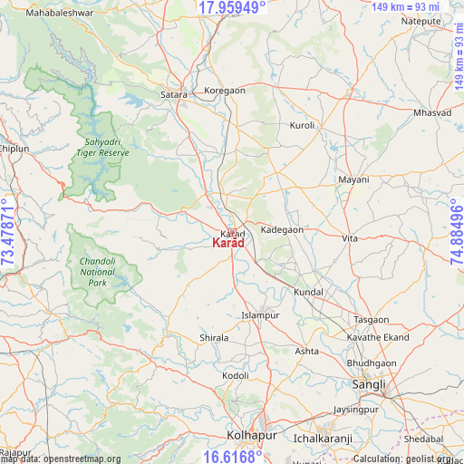
Karād GPS coordinates[2]
17° 17' 21.732" North, 74° 10' 54.588" East
| Map corner | latitude | longitude |
|---|---|---|
| Upper-left | 17.95949°, | 73.47871° |
| Center: | 17.28937°, | 74.18183° |
| Lower-right: | 16.6168°, | 74.88496° |
| Map W x H: | 149.3×149.3 km | = 92.8×92.8mi |
| max Lat: | 34.9274° ⇑74% North |
| Karād: | 17.28937° |
| min Lat: | ⇓26% South 8.09008° |
| min Long | Karād | max Long |
| 68.82655° | 74.18183° | 96.81° |
| W 11.5%⇐ | ⇒88.5% E |
Elevation
Elevation of Karād is 579 m = 1900 ft, and this is 283.4 m = 930 ft above average elevation for this country.
| Max E: |
3681 m = 12077 ft | 12.9% |
| Karād | 579 m 1900 ft | |
| Avg. | 295.6 m = 970 ft | |
Min E: |
1 m = 3 ft | 87.1% |
See also: Karād elevation on elevation.city.
Geographical zone
Karād is located in North Torrid zone (between Equator and Tropic of Cancer). Distance of this Northern Tropic circle is 683.5 km =424.7 mi to North.| Distance of | km | miles | from Karād |
|---|---|---|---|
| North Pole | 8084.7 | 5023.6 | to North |
| Arctic Circle | 5478.8 | 3404.4 | to North |
| Tropic Cancer | 683.5 | 424.7 | to North |
| Equator | 1922.4 | 1194.5 | to South |


Nearby cities:
15 places around Karād: (largest is in red/bold)
• Ashta
44.9 km =27.9 mi,  147°
147°
• Bhudgaon
61.4 km =38.2 mi,  133°
133°
• Jaisingpur
69.4 km =43.1 mi, 145°
• Kodoli
45.9 km =28.5 mi,  178°
178°
• Kolhāpur
66.2 km =41.1 mi, 175°
• Koynanagar
45.7 km =28.4 mi,  285°
285°
• Malkapur
3.1 km =1.9 mi,  192°
192°
• Malkāpur
48.8 km =30.3 mi,  212°
212°
• Panhāla
53.6 km =33.3 mi, 188°
• Pātan
31.3 km =19.4 mi, 287°
• Rahimatpur
33.7 km =20.9 mi,  3°
3°
• Satara
48.4 km =30.1 mi,  335°
335°
• Sāngli
63.2 km =39.3 mi,  139°
139°
• Tāsgaon
52.7 km =32.7 mi,  122°
122°
• Vite
37.8 km =23.5 mi,  92°
92°
Sources, notices
• [Note1] Compared only with cities in India existing in our database
• [Src1] Map data: © OpenStreetMap contributors (CC-BY-SA)
• [Src2] Other city data from geonames.org with taken over terms of usage.
• [Src3] Geographical zone / Annual Mean Temperature by Robert A. Rohde @ Wikipedia
