Devakottai geodata
Devakottai (Tamil Nadu) is a populated place; located in India in Asia/Kolkata (GMT+5.5) time zone. With population of 41,568 people, there are 1064 cities with bigger population in this country. Compared to other cities in India, 96.6% of cities are located further ↑North; 57.2% of cities are located further ←West and 78.5% of cities have higher elevation than Devakottai. Note1


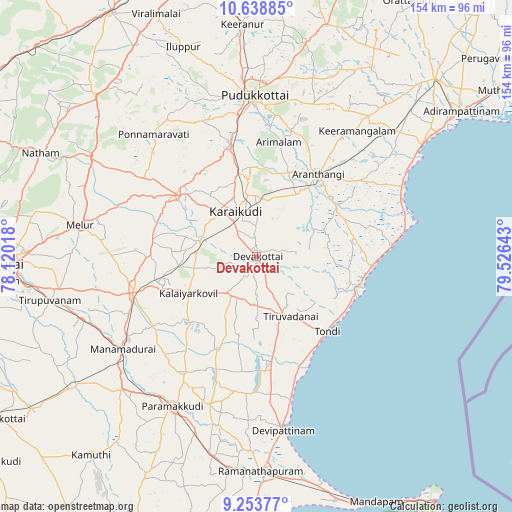
Devakottai GPS coordinates[2]
9° 56' 49.344" North, 78° 49' 23.88" East
| Map corner | latitude | longitude |
|---|---|---|
| Upper-left | 10.63885°, | 78.12018° |
| Center: | 9.94704°, | 78.8233° |
| Lower-right: | 9.25377°, | 79.52643° |
| Map W x H: | 154×154 km | = 95.7×95.7mi |
| max Lat: | 34.9274° ⇑96.6% North |
| Devakottai: | 9.94704° |
| min Lat: | ⇓3.4% South 8.09008° |
| min Long | Devakottai | max Long |
| 68.82655° | 78.8233° | 96.81° |
| W 57.2%⇐ | ⇒42.8% E |
Elevation
Elevation of Devakottai is 53 m = 174 ft, and this is 242.6 m = 796 ft below average elevation for this country.
| Max E: |
3681 m = 12077 ft | 78.5% |
| Avg. | 295.6 m = 970 ft | |
| Devakottai | 53 m = 174 ft | |
Min E: |
1 m = 3 ft | 21.5% |
See also: Devakottai elevation on elevation.city.
Geographical zone
Devakottai is located in North Torrid zone (between Equator and Tropic of Cancer). Distance of Equator is 1106 km =687.2 mi to South.| Distance of | km | miles | from Devakottai |
|---|---|---|---|
| North Pole | 8901.1 | 5530.9 | to North |
| Arctic Circle | 6295.2 | 3911.7 | to North |
| Tropic Cancer | 1499.9 | 932 | to North |
| Equator | 1106 | 687.2 | to South |


Nearby cities:
15 places around Devakottai: (largest is in red/bold)
• Arantāngi
31.1 km =19.3 mi,  36°
36°
• Arimalam
34.9 km =21.7 mi,  10°
10°
• Kanadukattan
25.5 km =15.8 mi,  349°
349°
• Kottaiyūr
18.3 km =11.4 mi, 350°
• Kāraikkudi
14.6 km =9.1 mi,  335°
335°
• Manamadurai
49.2 km =30.6 mi,  231°
231°
• Mangalam
28.5 km =17.7 mi,  224°
224°
• Nambutalai
31.6 km =19.6 mi,  140°
140°
• Nāttarasankottai
30.8 km =19.1 mi,  253°
253°
• Pallattūr
22.2 km =13.8 mi, 354°
• Ponnamarāvati
48.6 km =30.2 mi,  319°
319°
• Pudukkottai
48.3 km =30 mi,  359°
359°
• Sivaganga
38.8 km =24.1 mi, 253°
• Tiruppālaikudi
45.8 km =28.5 mi,  167°
167°
• Tondi
31.2 km =19.4 mi, 136°
Sources, notices
• [Note1] Compared only with cities in India existing in our database
• [Src1] Map data: © OpenStreetMap contributors (CC-BY-SA)
• [Src2] Other city data from geonames.org with taken over terms of usage.
• [Src3] Geographical zone / Annual Mean Temperature by Robert A. Rohde @ Wikipedia
