Nāttarasankottai geodata
Nāttarasankottai (Tamil Nadu) is a populated place; located in India in Asia/Kolkata (GMT+5.5) time zone. With population of 5,920 people, there are 3296 cities with bigger population in this country. Compared to other cities in India, 96.8% of cities are located further ↑North; 54.7% of cities are located further ←West and 71% of cities have higher elevation than Nāttarasankottai. Note1


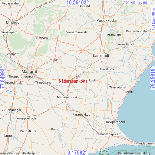
Nāttarasankottai GPS coordinates[2]
9° 52' 8.58" North, 78° 33' 10.98" East
| Map corner | latitude | longitude |
|---|---|---|
| Upper-left | 10.56103°, | 77.84993° |
| Center: | 9.86905°, | 78.55305° |
| Lower-right: | 9.17562°, | 79.25618° |
| Map W x H: | 154×154 km | = 95.7×95.7mi |
| max Lat: | 34.9274° ⇑96.8% North |
| Nāttarasankottai: | 9.86905° |
| min Lat: | ⇓3.2% South 8.09008° |
| min Long | Nāttarasankott | max Long |
| 68.82655° | 78.55305° | 96.81° |
| W 54.7%⇐ | ⇒45.3% E |
Elevation
Elevation of Nāttarasankottai is 88 m = 289 ft, and this is 207.6 m = 681 ft below average elevation for this country.
| Max E: |
3681 m = 12077 ft | 71% |
| Avg. | 295.6 m = 970 ft | |
| Nāttarasankottai | 88 m = 289 ft | |
Min E: |
1 m = 3 ft | 29% |
See also: India elevation on elevation.city.
Geographical zone
Nāttarasankottai is located in North Torrid zone (between Equator and Tropic of Cancer). Distance of Equator is 1097.3 km =681.8 mi to South.| Distance of | km | miles | from Nāttarasankottai |
|---|---|---|---|
| North Pole | 8909.7 | 5536.2 | to North |
| Arctic Circle | 6303.8 | 3917 | to North |
| Tropic Cancer | 1508.6 | 937.4 | to North |
| Equator | 1097.3 | 681.8 | to South |


Nearby cities:
15 places around Nāttarasankottai: (largest is in red/bold)
• Abirāmam
49 km =30.4 mi,  194°
194°
• Devakottai
30.8 km =19.1 mi,  73°
73°
• Kanadukattan
41.8 km =26 mi,  36°
36°
• Kottaiyūr
37.7 km =23.4 mi, 44°
• Kāraikkudi
32.1 km =19.9 mi,  47°
47°
• Madurai
47.8 km =29.7 mi,  276°
276°
• Manamadurai
23.6 km =14.7 mi,  202°
202°
• Mangalam
15 km =9.3 mi,  140°
140°
• Melur
29.6 km =18.4 mi,  307°
307°
• Nambutalai
52.2 km =32.4 mi,  107°
107°
• Pallattūr
41.2 km =25.6 mi, 41°
• Paramagudi
36.1 km =22.4 mi,  173°
173°
• Ponnamarāvati
45.8 km =28.5 mi,  357°
357°
• Sivaganga
8 km =5 mi,  252°
252°
• Tiruppuvanam
32.7 km =20.3 mi,  261°
261°
Sources, notices
• [Note1] Compared only with cities in India existing in our database
• [Src1] Map data: © OpenStreetMap contributors (CC-BY-SA)
• [Src2] Other city data from geonames.org with taken over terms of usage.
• [Src3] Geographical zone / Annual Mean Temperature by Robert A. Rohde @ Wikipedia
