Omalur geodata
Omalur (Tamil Nadu) is a populated place; located in India in Asia/Kolkata (GMT+5.5) time zone. With population of 12,701 people, there are 2679 cities with bigger population in this country. Compared to other cities in India, 90.5% of cities are located further ↑North; 50.9% of cities are located further →East and 64.2% of cities have lower elevation than Omalur. Note1


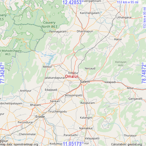
Omalur GPS coordinates[2]
11° 44' 27.564" North, 78° 2' 44.124" East
| Map corner | latitude | longitude |
|---|---|---|
| Upper-left | 12.42853°, | 77.34247° |
| Center: | 11.74099°, | 78.04559° |
| Lower-right: | 11.05173°, | 78.74872° |
| Map W x H: | 153.1×153.1 km | = 95.1×95.1mi |
| max Lat: | 34.9274° ⇑90.5% North |
| Omalur: | 11.74099° |
| min Lat: | ⇓9.5% South 8.09008° |
| min Long | Omalur | max Long |
| 68.82655° | 78.04559° | 96.81° |
| W 49.1%⇐ | ⇒50.9% E |
Elevation
Elevation of Omalur is 280 m = 919 ft, and this is 15.6 m = 51 ft below average elevation for this country.
| Max E: |
3681 m = 12077 ft | 35.8% |
| Avg. | 295.6 m = 970 ft | |
| Omalur | 280 m = 919 ft | |
Min E: |
1 m = 3 ft | 64.2% |
See also: India elevation on elevation.city.
Geographical zone
Omalur is located in North Torrid zone (between Equator and Tropic of Cancer). Distance of this Northern Tropic circle is 1300.4 km =808 mi to North.| Distance of | km | miles | from Omalur |
|---|---|---|---|
| North Pole | 8701.6 | 5406.9 | to North |
| Arctic Circle | 6095.7 | 3787.7 | to North |
| Tropic Cancer | 1300.4 | 808 | to North |
| Equator | 1305.5 | 811.2 | to South |


Nearby cities:
15 places around Omalur: (largest is in red/bold)
• Ammāpettai
35.6 km =22.1 mi,  247°
247°
• Idappadi
28.3 km =17.6 mi,  232°
232°
• Ilampillai
15.5 km =9.6 mi,  195°
195°
• Jalakandapuram
19.4 km =12.1 mi,  255°
255°
• Konganāpuram
24.6 km =15.3 mi,  219°
219°
• Mallasamudram
27.6 km =17.1 mi,  183°
183°
• Mallāpuram
34.7 km =21.6 mi,  39°
39°
• Mettur
27.2 km =16.9 mi,  281°
281°
• Māllūr
24.2 km =15 mi,  154°
154°
• Nangavalli
17 km =10.6 mi, 277°
• Nāmagiripettai
40 km =24.9 mi,  142°
142°
• Rasipuram
34.8 km =21.6 mi, 153°
• Salem
15.4 km =9.6 mi,  129°
129°
• Tāramangalam
9.7 km =6 mi,  237°
237°
• Āttayyāmpatti
23.2 km =14.4 mi, 177°
Sources, notices
• [Note1] Compared only with cities in India existing in our database
• [Src1] Map data: © OpenStreetMap contributors (CC-BY-SA)
• [Src2] Other city data from geonames.org with taken over terms of usage.
• [Src3] Geographical zone / Annual Mean Temperature by Robert A. Rohde @ Wikipedia
