Āttayyāmpatti geodata
Āttayyāmpatti (Tamil Nadu) is a populated place; located in India in Asia/Kolkata (GMT+5.5) time zone. With population of 13,627 people, there are 2601 cities with bigger population in this country. Compared to other cities in India, 91.2% of cities are located further ↑North; 50.8% of cities are located further →East and 57.1% of cities have lower elevation than Āttayyāmpatti. Note1


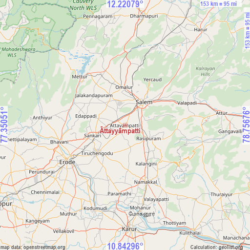
Āttayyāmpatti GPS coordinates[2]
11° 31' 57.792" North, 78° 3' 13.068" East
| Map corner | latitude | longitude |
|---|---|---|
| Upper-left | 12.22079°, | 77.35051° |
| Center: | 11.53272°, | 78.05363° |
| Lower-right: | 10.84296°, | 78.75676° |
| Map W x H: | 153.2×153.2 km | = 95.2×95.2mi |
| max Lat: | 34.9274° ⇑91.2% North |
| Āttayyāmpatti: | 11.53272° |
| min Lat: | ⇓8.8% South 8.09008° |
| min Long | Āttayyāmpatti | max Long |
| 68.82655° | 78.05363° | 96.81° |
| W 49.2%⇐ | ⇒50.8% E |
Elevation
Elevation of Āttayyāmpatti is 235 m = 771 ft, and this is 60.6 m = 199 ft below average elevation for this country.
| Max E: |
3681 m = 12077 ft | 42.9% |
| Avg. | 295.6 m = 970 ft | |
| Āttayyāmpatti | 235 m = 771 ft | |
Min E: |
1 m = 3 ft | 57.1% |
See also: India elevation on elevation.city.
Geographical zone
Āttayyāmpatti is located in North Torrid zone (between Equator and Tropic of Cancer). Distance of Equator is 1282.3 km =796.8 mi to South.| Distance of | km | miles | from Āttayyāmpatti |
|---|---|---|---|
| North Pole | 8724.7 | 5421.3 | to North |
| Arctic Circle | 6118.9 | 3802.1 | to North |
| Tropic Cancer | 1323.6 | 822.4 | to North |
| Equator | 1282.3 | 796.8 | to South |


Nearby cities:
15 places around Āttayyāmpatti: (largest is in red/bold)
• Ammāpettai
35.2 km =21.9 mi,  285°
285°
• Idappadi
24.1 km =15 mi,  284°
284°
• Ilampillai
9.7 km =6 mi,  328°
328°
• Jalakandapuram
26.9 km =16.7 mi,  313°
313°
• Konganāpuram
17.2 km =10.7 mi, 284°
• Mallasamudram
5 km =3.1 mi,  209°
209°
• Māllūr
9.6 km =6 mi,  82°
82°
• Nangavalli
31 km =19.3 mi, 325°
• Nāmagiripettai
24.9 km =15.5 mi,  110°
110°
• Nāmakkal
36.7 km =22.8 mi,  160°
160°
• Omalur
23.2 km =14.4 mi,  357°
357°
• Rasipuram
16.6 km =10.3 mi,  119°
119°
• Salem
17.4 km =10.8 mi,  39°
39°
• Tiruchengode
24.3 km =15.1 mi,  225°
225°
• Tāramangalam
20.1 km =12.5 mi, 333°
Sources, notices
• [Note1] Compared only with cities in India existing in our database
• [Src1] Map data: © OpenStreetMap contributors (CC-BY-SA)
• [Src2] Other city data from geonames.org with taken over terms of usage.
• [Src3] Geographical zone / Annual Mean Temperature by Robert A. Rohde @ Wikipedia
