Idappadi geodata
Idappadi (Tamil Nadu) is a populated place; located in India in Asia/Kolkata (GMT+5.5) time zone. With population of 51,642 people, there are 865 cities with bigger population in this country. Compared to other cities in India, 91% of cities are located further ↑North; 53.2% of cities are located further →East and 51.3% of cities have lower elevation than Idappadi. Note1


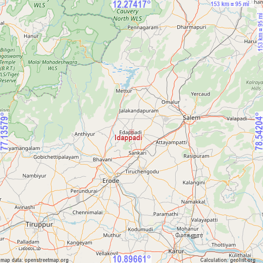
Idappadi GPS coordinates[2]
11° 35' 10.464" North, 77° 50' 20.076" East
| Map corner | latitude | longitude |
|---|---|---|
| Upper-left | 12.27417°, | 77.13579° |
| Center: | 11.58624°, | 77.83891° |
| Lower-right: | 10.89661°, | 78.54204° |
| Map W x H: | 153.2×153.2 km | = 95.2×95.2mi |
| max Lat: | 34.9274° ⇑91% North |
| Idappadi: | 11.58624° |
| min Lat: | ⇓9% South 8.09008° |
| min Long | Idappadi | max Long |
| 68.82655° | 77.83891° | 96.81° |
| W 46.8%⇐ | ⇒53.2% E |
Elevation
Elevation of Idappadi is 209 m = 686 ft, and this is 86.6 m = 284 ft below average elevation for this country.
| Max E: |
3681 m = 12077 ft | 48.7% |
| Avg. | 295.6 m = 970 ft | |
| Idappadi | 209 m = 686 ft | |
Min E: |
1 m = 3 ft | 51.3% |
See also: Idappadi elevation on elevation.city.
Geographical zone
Idappadi is located in North Torrid zone (between Equator and Tropic of Cancer). Distance of Equator is 1288.3 km =800.5 mi to South.| Distance of | km | miles | from Idappadi |
|---|---|---|---|
| North Pole | 8718.8 | 5417.6 | to North |
| Arctic Circle | 6112.9 | 3798.4 | to North |
| Tropic Cancer | 1317.6 | 818.7 | to North |
| Equator | 1288.3 | 800.5 | to South |


Nearby cities:
15 places around Idappadi: (largest is in red/bold)
• Ammāpettai
11.1 km =6.9 mi,  289°
289°
• Anthiyur
27.1 km =16.8 mi,  267°
267°
• Bhavāni
23.2 km =14.4 mi,  227°
227°
• Erode
29.7 km =18.5 mi,  204°
204°
• Ilampillai
18.4 km =11.4 mi,  82°
82°
• Jalakandapuram
12.9 km =8 mi,  16°
16°
• Konganāpuram
6.9 km =4.3 mi,  104°
104°
• Mallasamudram
23.4 km =14.5 mi,  116°
116°
• Mettur
22.8 km =14.2 mi,  349°
349°
• Māllūr
33.2 km =20.6 mi, 98°
• Nangavalli
20.3 km =12.6 mi, 16°
• Omalur
28.3 km =17.6 mi,  52°
52°
• Tiruchengode
23.7 km =14.7 mi,  165°
165°
• Tāramangalam
18.7 km =11.6 mi, 50°
• Āttayyāmpatti
24.1 km =15 mi, 104°
Sources, notices
• [Note1] Compared only with cities in India existing in our database
• [Src1] Map data: © OpenStreetMap contributors (CC-BY-SA)
• [Src2] Other city data from geonames.org with taken over terms of usage.
• [Src3] Geographical zone / Annual Mean Temperature by Robert A. Rohde @ Wikipedia
