Ammāpettai geodata
Ammāpettai (Tamil Nadu) is a populated place; located in India in Asia/Kolkata (GMT+5.5) time zone. With population of 8,552 people, there are 3075 cities with bigger population in this country. Compared to other cities in India, 90.8% of cities are located further ↑North; 54.4% of cities are located further →East and 52.7% of cities have higher elevation than Ammāpettai. Note1


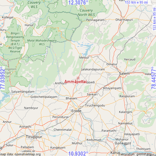
Ammāpettai GPS coordinates[2]
11° 37' 11.1" North, 77° 44' 33.504" East
| Map corner | latitude | longitude |
|---|---|---|
| Upper-left | 12.3076°, | 77.03952° |
| Center: | 11.61975°, | 77.74264° |
| Lower-right: | 10.9302°, | 78.44577° |
| Map W x H: | 153.2×153.2 km | = 95.2×95.2mi |
| max Lat: | 34.9274° ⇑90.8% North |
| Ammāpettai: | 11.61975° |
| min Lat: | ⇓9.2% South 8.09008° |
| min Long | Ammāpettai | max Long |
| 68.82655° | 77.74264° | 96.81° |
| W 45.6%⇐ | ⇒54.4% E |
Elevation
Elevation of Ammāpettai is 186 m = 610 ft, and this is 109.6 m = 360 ft below average elevation for this country.
| Max E: |
3681 m = 12077 ft | 52.7% |
| Avg. | 295.6 m = 970 ft | |
| Ammāpettai | 186 m = 610 ft | |
Min E: |
1 m = 3 ft | 47.3% |
See also: India elevation on elevation.city.
Geographical zone
Ammāpettai is located in North Torrid zone (between Equator and Tropic of Cancer). Distance of Equator is 1292 km =802.8 mi to South.| Distance of | km | miles | from Ammāpettai |
|---|---|---|---|
| North Pole | 8715.1 | 5415.3 | to North |
| Arctic Circle | 6109.2 | 3796.1 | to North |
| Tropic Cancer | 1313.9 | 816.4 | to North |
| Equator | 1292 | 802.8 | to South |


Nearby cities:
15 places around Ammāpettai: (largest is in red/bold)
• Anthiyur
17.3 km =10.7 mi,  253°
253°
• Bhavāni
20.5 km =12.7 mi,  198°
198°
• Erode
30.8 km =19.1 mi,  183°
183°
• Gobichettipalayam
37.5 km =23.3 mi,  240°
240°
• Idappadi
11.1 km =6.9 mi,  109°
109°
• Ilampillai
28.8 km =17.9 mi,  92°
92°
• Jalakandapuram
16.6 km =10.3 mi,  58°
58°
• Konganāpuram
18 km =11.2 mi, 107°
• Mallasamudram
34.4 km =21.4 mi, 114°
• Mettur
19.7 km =12.2 mi,  18°
18°
• Nangavalli
22.6 km =14 mi,  45°
45°
• Omalur
35.6 km =22.1 mi,  67°
67°
• Tiruchengode
31.4 km =19.5 mi,  148°
148°
• Tāramangalam
26.1 km =16.2 mi, 71°
• Āttayyāmpatti
35.2 km =21.9 mi, 105°
Sources, notices
• [Note1] Compared only with cities in India existing in our database
• [Src1] Map data: © OpenStreetMap contributors (CC-BY-SA)
• [Src2] Other city data from geonames.org with taken over terms of usage.
• [Src3] Geographical zone / Annual Mean Temperature by Robert A. Rohde @ Wikipedia
