Memāri geodata
Memāri (West Bengal) is a populated place; located in India in Asia/Kolkata (GMT+5.5) time zone. With population of 44,448 people, there are 994 cities with bigger population in this country. Compared to other cities in India, 52.7% of cities are located further ↓South; 91.3% of cities are located further ←West and 86.8% of cities have higher elevation than Memāri. Note1


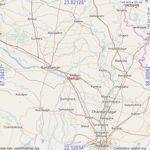
Memāri GPS coordinates[2]
23° 10' 35.292" North, 88° 5' 50.964" East
| Map corner | latitude | longitude |
|---|---|---|
| Upper-left | 23.82128°, | 87.39437° |
| Center: | 23.17647°, | 88.09749° |
| Lower-right: | 22.52854°, | 88.80062° |
| Map W x H: | 143.7×143.7 km | = 89.3×89.3mi |
| max Lat: | 34.9274° ⇑47.3% North |
| Memāri: | 23.17647° |
| min Lat: | ⇓52.7% South 8.09008° |
| min Long | Memāri | max Long |
| 68.82655° | 88.09749° | 96.81° |
| W 91.3%⇐ | ⇒8.7% E |
Elevation
Elevation of Memāri is 25 m = 82 ft, and this is 270.6 m = 888 ft below average elevation for this country.
| Max E: |
3681 m = 12077 ft | 86.8% |
| Avg. | 295.6 m = 970 ft | |
| Memāri | 25 m = 82 ft | |
Min E: |
1 m = 3 ft | 13.2% |
See also: Memāri elevation on elevation.city.
Geographical zone
Memāri is located in North Torrid zone (between Equator and Tropic of Cancer). Distance of this Northern Tropic circle is 28.9 km =18 mi to North.| Distance of | km | miles | from Memāri |
|---|---|---|---|
| North Pole | 7430.1 | 4616.8 | to North |
| Arctic Circle | 4824.2 | 2997.6 | to North |
| Tropic Cancer | 28.9 | 18 | to North |
| Equator | 2577 | 1601.3 | to South |


Nearby cities:
15 places around Memāri: (largest is in red/bold)
• Barddhamān
26.1 km =16.2 mi,  289°
289°
• Bāgnān
27.4 km =17 mi,  171°
171°
• Bānsbāria
39.7 km =24.7 mi,  128°
128°
• Haripur
30.1 km =18.7 mi,  152°
152°
• Hugli
42.7 km =26.5 mi, 134°
• Hālīsahar
42.6 km =26.5 mi, 129°
• Kesabpur
28.7 km =17.8 mi,  143°
143°
• Kālna
27.5 km =17.1 mi,  80°
80°
• Kānchrāpāra
41.5 km =25.8 mi, 125°
• Navadwīp
37.7 km =23.4 mi,  47°
47°
• Pandua
22.4 km =13.9 mi,  120°
120°
• Shāntipur
35.2 km =21.9 mi, 77°
• Singur
43 km =26.7 mi,  161°
161°
• Srirāmpur
26.6 km =16.5 mi,  197°
197°
• Tarakeswar
33.4 km =20.8 mi,  194°
194°
Sources, notices
• [Note1] Compared only with cities in India existing in our database
• [Src1] Map data: © OpenStreetMap contributors (CC-BY-SA)
• [Src2] Other city data from geonames.org with taken over terms of usage.
• [Src3] Geographical zone / Annual Mean Temperature by Robert A. Rohde @ Wikipedia
