Barddhamān geodata
Barddhamān (West Bengal) is a populated place; located in India in Asia/Kolkata (GMT+5.5) time zone. With population of 301,725 people, there are 144 cities with bigger population in this country. Compared to other cities in India, 53.3% of cities are located further ↓South; 90.9% of cities are located further ←West and 83.9% of cities have higher elevation than Barddhamān. Note1


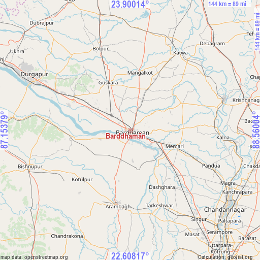
Barddhamān GPS coordinates[2]
23° 15' 20.592" North, 87° 51' 24.876" East
| Map corner | latitude | longitude |
|---|---|---|
| Upper-left | 23.90014°, | 87.15379° |
| Center: | 23.25572°, | 87.85691° |
| Lower-right: | 22.60817°, | 88.56004° |
| Map W x H: | 143.7×143.7 km | = 89.3×89.3mi |
| max Lat: | 34.9274° ⇑46.7% North |
| Barddhamān: | 23.25572° |
| min Lat: | ⇓53.3% South 8.09008° |
| min Long | Barddhamān | max Long |
| 68.82655° | 87.85691° | 96.81° |
| W 90.9%⇐ | ⇒9.1% E |
Elevation
Elevation of Barddhamān is 34 m = 112 ft, and this is 261.6 m = 858 ft below average elevation for this country.
| Max E: |
3681 m = 12077 ft | 83.9% |
| Avg. | 295.6 m = 970 ft | |
| Barddhamān | 34 m = 112 ft | |
Min E: |
1 m = 3 ft | 16.1% |
See also: Barddhamān elevation on elevation.city.
Geographical zone
Barddhamān is located in North Torrid zone (between Equator and Tropic of Cancer). Distance of this Northern Tropic circle is 20.1 km =12.5 mi to North.| Distance of | km | miles | from Barddhamān |
|---|---|---|---|
| North Pole | 7421.3 | 4611.4 | to North |
| Arctic Circle | 4815.4 | 2992.1 | to North |
| Tropic Cancer | 20.1 | 12.5 | to North |
| Equator | 2585.8 | 1606.7 | to South |


Nearby cities:
15 places around Barddhamān: (largest is in red/bold)
• Arāmbāgh
42.1 km =26.2 mi,  190°
190°
• Bolpur
48.1 km =29.9 mi,  340°
340°
• Bāgnān
46 km =28.6 mi,  141°
141°
• Guskhara
29.2 km =18.1 mi,  334°
334°
• Haripur
52.3 km =32.5 mi,  132°
132°
• Kesabpur
52.4 km =32.6 mi, 127°
• Kālna
51.9 km =32.2 mi,  94°
94°
• Kātoya
51.7 km =32.1 mi,  32°
32°
• Memāri
26.1 km =16.2 mi,  109°
109°
• Pandua
48.3 km =30 mi, 114°
• Pātrasāer
33.7 km =20.9 mi,  258°
258°
• Pātuli
53.1 km =33 mi,  51°
51°
• Sonāmukhi
45.6 km =28.3 mi,  276°
276°
• Srirāmpur
38 km =23.6 mi,  154°
154°
• Tarakeswar
44.1 km =27.4 mi,  158°
158°
Sources, notices
• [Note1] Compared only with cities in India existing in our database
• [Src1] Map data: © OpenStreetMap contributors (CC-BY-SA)
• [Src2] Other city data from geonames.org with taken over terms of usage.
• [Src3] Geographical zone / Annual Mean Temperature by Robert A. Rohde @ Wikipedia
