Navadwīp geodata
Navadwīp (West Bengal) is a populated place; located in India in Asia/Kolkata (GMT+5.5) time zone. With population of 111,123 people, there are 402 cities with bigger population in this country. Compared to other cities in India, 54.3% of cities are located further ↓South; 93.4% of cities are located further ←West and 90.4% of cities have higher elevation than Navadwīp. Note1


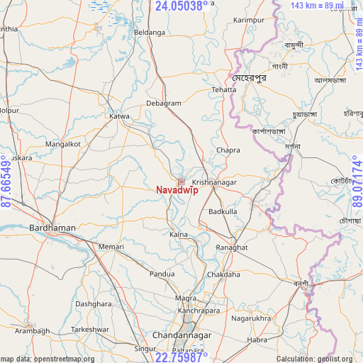
Navadwīp GPS coordinates[2]
23° 24' 24.12" North, 88° 22' 6.996" East
| Map corner | latitude | longitude |
|---|---|---|
| Upper-left | 24.05038°, | 87.66549° |
| Center: | 23.4067°, | 88.36861° |
| Lower-right: | 22.75987°, | 89.07174° |
| Map W x H: | 143.5×143.5 km | = 89.2×89.2mi |
| max Lat: | 34.9274° ⇑45.7% North |
| Navadwīp: | 23.4067° |
| min Lat: | ⇓54.3% South 8.09008° |
| min Long | Navadwīp | max Long |
| 68.82655° | 88.36861° | 96.81° |
| W 93.4%⇐ | ⇒6.6% E |
Elevation
Elevation of Navadwīp is 17 m = 56 ft, and this is 278.6 m = 914 ft below average elevation for this country.
| Max E: |
3681 m = 12077 ft | 90.4% |
| Avg. | 295.6 m = 970 ft | |
| Navadwīp | 17 m = 56 ft | |
Min E: |
1 m = 3 ft | 9.6% |
See also: Navadwīp elevation on elevation.city.
Geographical zone
Navadwīp is located in North Torrid zone (between Equator and Tropic of Cancer). Distance of this Northern Tropic circle is 3.3 km =2.1 mi to North.| Distance of | km | miles | from Navadwīp |
|---|---|---|---|
| North Pole | 7404.5 | 4600.9 | to North |
| Arctic Circle | 4798.6 | 2981.7 | to North |
| Tropic Cancer | 3.3 | 2.1 | to North |
| Equator | 2602.6 | 1617.2 | to South |


Nearby cities:
15 places around Navadwīp: (largest is in red/bold)
• Aistala
33.2 km =20.6 mi,  139°
139°
• Bagulā
28.9 km =18 mi,  105°
105°
• Kalyani
48.5 km =30.1 mi,  166°
166°
• Kesabpur
49.9 km =31 mi,  192°
192°
• Krishnanagar
12.5 km =7.8 mi,  90°
90°
• Kālna
20.8 km =12.9 mi,  181°
181°
• Kānchrāpāra
50 km =31.1 mi, 172°
• Kātoya
35.8 km =22.2 mi,  317°
317°
• Madanpur
46.3 km =28.8 mi,  164°
164°
• Memāri
37.7 km =23.4 mi,  227°
227°
• Muragācha
14.6 km =9.1 mi,  10°
10°
• Pandua
37.8 km =23.5 mi, 192°
• Pātuli
19.4 km =12.1 mi,  326°
326°
• Rānāghāt
32.6 km =20.3 mi, 141°
• Shāntipur
18.9 km =11.7 mi, 159°
Sources, notices
• [Note1] Compared only with cities in India existing in our database
• [Src1] Map data: © OpenStreetMap contributors (CC-BY-SA)
• [Src2] Other city data from geonames.org with taken over terms of usage.
• [Src3] Geographical zone / Annual Mean Temperature by Robert A. Rohde @ Wikipedia
