Mau geodata
Mau (Uttar Pradesh) is a populated place; located in India in Asia/Kolkata (GMT+5.5) time zone. With population of 246,050 people, there are 174 cities with bigger population in this country. Compared to other cities in India, 70% of cities are located further ↓South; 80.9% of cities are located further ←West and 73.3% of cities have higher elevation than Mau. Note1


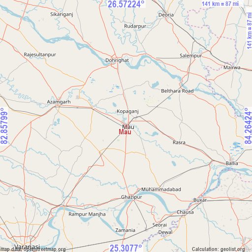
Mau GPS coordinates[2]
25° 56' 30.012" North, 83° 33' 39.996" East
| Map corner | latitude | longitude |
|---|---|---|
| Upper-left | 26.57224°, | 82.85799° |
| Center: | 25.94167°, | 83.56111° |
| Lower-right: | 25.3077°, | 84.26424° |
| Map W x H: | 140.6×140.6 km | = 87.4×87.4mi |
| max Lat: | 34.9274° ⇑30% North |
| Mau: | 25.94167° |
| min Lat: | ⇓70% South 8.09008° |
| min Long | Mau | max Long |
| 68.82655° | 83.56111° | 96.81° |
| W 80.9%⇐ | ⇒19.1% E |
Elevation
Elevation of Mau is 78 m = 256 ft, and this is 217.6 m = 714 ft below average elevation for this country.
| Max E: |
3681 m = 12077 ft | 73.3% |
| Avg. | 295.6 m = 970 ft | |
| Mau | 78 m = 256 ft | |
Min E: |
1 m = 3 ft | 26.7% |
See also: Mau elevation on elevation.city.
Geographical zone
Mau is located in North temperate zone (between Tropic of Cancer and the Arctic Circle). Distance of this Northern Tropic circle is 278.5 km =173.1 mi to South.| Distance of | km | miles | from Mau |
|---|---|---|---|
| North Pole | 7122.6 | 4425.8 | to North |
| Arctic Circle | 4516.7 | 2806.5 | to North |
| Tropic Cancer | 278.5 | 173.1 | to South |
| Equator | 2884.4 | 1792.3 | to South |


Nearby cities:
15 places around Mau: (largest is in red/bold)
• Azamgarh
40.3 km =25 mi,  290°
290°
• Bilariāganj
43.7 km =27.2 mi,  310°
310°
• Bilthra
38.9 km =24.2 mi,  58°
58°
• Chillupār
38.3 km =23.8 mi,  351°
351°
• Dohrighāt
37.1 km =23.1 mi, 351°
• Ghazīpur
39.9 km =24.8 mi,  176°
176°
• Ghosī
18.4 km =11.4 mi, 353°
• Jainpur
32.7 km =20.3 mi,  316°
316°
• Kopāganj
8.6 km =5.3 mi,  3°
3°
• Mehnagar
45 km =28 mi,  261°
261°
• Mubārakpur
31.6 km =19.6 mi,  301°
301°
• Muhammadābād
20.7 km =12.9 mi, 299°
• Muhammadābād
40.8 km =25.4 mi,  151°
151°
• Rasrā
30.8 km =19.1 mi,  107°
107°
• Sādāt
39.7 km =24.7 mi,  220°
220°
Sources, notices
• [Note1] Compared only with cities in India existing in our database
• [Src1] Map data: © OpenStreetMap contributors (CC-BY-SA)
• [Src2] Other city data from geonames.org with taken over terms of usage.
• [Src3] Geographical zone / Annual Mean Temperature by Robert A. Rohde @ Wikipedia
