Kopāganj geodata
Kopāganj (Uttar Pradesh) is a populated place; located in India in Asia/Kolkata (GMT+5.5) time zone. With population of 33,539 people, there are 1295 cities with bigger population in this country. Compared to other cities in India, 70.4% of cities are located further ↓South; 80.9% of cities are located further ←West and 73.3% of cities have higher elevation than Kopāganj. Note1


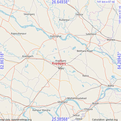
Kopāganj GPS coordinates[2]
26° 1' 9.228" North, 83° 33' 58.68" East
| Map corner | latitude | longitude |
|---|---|---|
| Upper-left | 26.64938°, | 82.86318° |
| Center: | 26.01923°, | 83.5663° |
| Lower-right: | 25.38568°, | 84.26943° |
| Map W x H: | 140.5×140.5 km | = 87.3×87.3mi |
| max Lat: | 34.9274° ⇑29.6% North |
| Kopāganj: | 26.01923° |
| min Lat: | ⇓70.4% South 8.09008° |
| min Long | Kopāganj | max Long |
| 68.82655° | 83.5663° | 96.81° |
| W 80.9%⇐ | ⇒19.1% E |
Elevation
Elevation of Kopāganj is 78 m = 256 ft, and this is 217.6 m = 714 ft below average elevation for this country.
| Max E: |
3681 m = 12077 ft | 73.3% |
| Avg. | 295.6 m = 970 ft | |
| Kopāganj | 78 m = 256 ft | |
Min E: |
1 m = 3 ft | 26.7% |
See also: India elevation on elevation.city.
Geographical zone
Kopāganj is located in North temperate zone (between Tropic of Cancer and the Arctic Circle). Distance of this Northern Tropic circle is 287.1 km =178.4 mi to South.| Distance of | km | miles | from Kopāganj |
|---|---|---|---|
| North Pole | 7114 | 4420.4 | to North |
| Arctic Circle | 4508.1 | 2801.2 | to North |
| Tropic Cancer | 287.1 | 178.4 | to South |
| Equator | 2893.1 | 1797.7 | to South |


Nearby cities:
15 places around Kopāganj: (largest is in red/bold)
• Azamgarh
38.6 km =24 mi,  278°
278°
• Bilariāganj
39.2 km =24.4 mi,  300°
300°
• Bilthra
34.6 km =21.5 mi,  69°
69°
• Chillupār
29.8 km =18.5 mi,  348°
348°
• Dohrighāt
28.7 km =17.8 mi, 348°
• Ghosī
10 km =6.2 mi,  344°
344°
• Gola Bāzār
42 km =26.1 mi,  329°
329°
• Jainpur
27.5 km =17.1 mi, 302°
• Lar
45.2 km =28.1 mi,  62°
62°
• Mau
8.6 km =5.3 mi,  183°
183°
• Mubārakpur
28.6 km =17.8 mi,  285°
285°
• Muhammadābād
18.6 km =11.6 mi, 275°
• Rasrā
34 km =21.1 mi,  121°
121°
• Rūdarpur
47.5 km =29.5 mi,  5°
5°
• Sādāt
46.8 km =29.1 mi,  214°
214°
Sources, notices
• [Note1] Compared only with cities in India existing in our database
• [Src1] Map data: © OpenStreetMap contributors (CC-BY-SA)
• [Src2] Other city data from geonames.org with taken over terms of usage.
• [Src3] Geographical zone / Annual Mean Temperature by Robert A. Rohde @ Wikipedia
