Sādāt geodata
Sādāt (Uttar Pradesh) is a populated place; located in India in Asia/Kolkata (GMT+5.5) time zone. With population of 11,211 people, there are 2812 cities with bigger population in this country. Compared to other cities in India, 68.2% of cities are located further ↓South; 80.3% of cities are located further ←West and 72.9% of cities have higher elevation than Sādāt. Note1


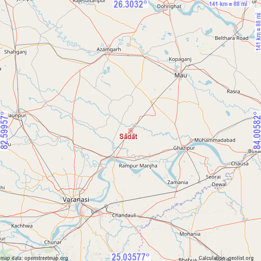
Sādāt GPS coordinates[2]
25° 40' 16.212" North, 83° 18' 9.684" East
| Map corner | latitude | longitude |
|---|---|---|
| Upper-left | 26.3032°, | 82.59957° |
| Center: | 25.67117°, | 83.30269° |
| Lower-right: | 25.03577°, | 84.00582° |
| Map W x H: | 140.9×140.9 km | = 87.6×87.6mi |
| max Lat: | 34.9274° ⇑31.8% North |
| Sādāt: | 25.67117° |
| min Lat: | ⇓68.2% South 8.09008° |
| min Long | Sādāt | max Long |
| 68.82655° | 83.30269° | 96.81° |
| W 80.3%⇐ | ⇒19.7% E |
Elevation
Elevation of Sādāt is 80 m = 262 ft, and this is 215.6 m = 707 ft below average elevation for this country.
| Max E: |
3681 m = 12077 ft | 72.9% |
| Avg. | 295.6 m = 970 ft | |
| Sādāt | 80 m = 262 ft | |
Min E: |
1 m = 3 ft | 27.1% |
See also: India elevation on elevation.city.
Geographical zone
Sādāt is located in North temperate zone (between Tropic of Cancer and the Arctic Circle). Distance of this Northern Tropic circle is 248.4 km =154.3 mi to South.| Distance of | km | miles | from Sādāt |
|---|---|---|---|
| North Pole | 7152.7 | 4444.5 | to North |
| Arctic Circle | 4546.8 | 2825.2 | to North |
| Tropic Cancer | 248.4 | 154.3 | to South |
| Equator | 2854.4 | 1773.6 | to South |


Nearby cities:
15 places around Sādāt: (largest is in red/bold)
• Azamgarh
45.7 km =28.4 mi,  344°
344°
• Chandauli
46.1 km =28.6 mi,  184°
184°
• Ghazīpur
30 km =18.6 mi,  109°
109°
• Kirākat
38.9 km =24.2 mi,  264°
264°
• Kopāganj
46.8 km =29.1 mi,  34°
34°
• Mau
39.7 km =24.7 mi,  40°
40°
• Mehnagar
29.7 km =18.5 mi,  321°
321°
• Mubārakpur
46.4 km =28.8 mi,  358°
358°
• Mughal Sarāi
46.9 km =29.1 mi,  203°
203°
• Muhammadābād
41.1 km =25.5 mi,  11°
11°
• Muhammadābād
45.8 km =28.5 mi,  97°
97°
• Nizāmābād
49 km =30.4 mi,  330°
330°
• Saidpur
16.8 km =10.4 mi,  208°
208°
• Varanasi
49.1 km =30.5 mi,  216°
216°
• Zamānia
37.9 km =23.5 mi,  137°
137°
Sources, notices
• [Note1] Compared only with cities in India existing in our database
• [Src1] Map data: © OpenStreetMap contributors (CC-BY-SA)
• [Src2] Other city data from geonames.org with taken over terms of usage.
• [Src3] Geographical zone / Annual Mean Temperature by Robert A. Rohde @ Wikipedia
