Bilthra geodata
Bilthra (Uttar Pradesh) is a populated place; located in India in Asia/Kolkata (GMT+5.5) time zone. With population of 17,228 people, there are 2266 cities with bigger population in this country. Compared to other cities in India, 71.4% of cities are located further ↓South; 81.7% of cities are located further ←West and 74.4% of cities have higher elevation than Bilthra. Note1


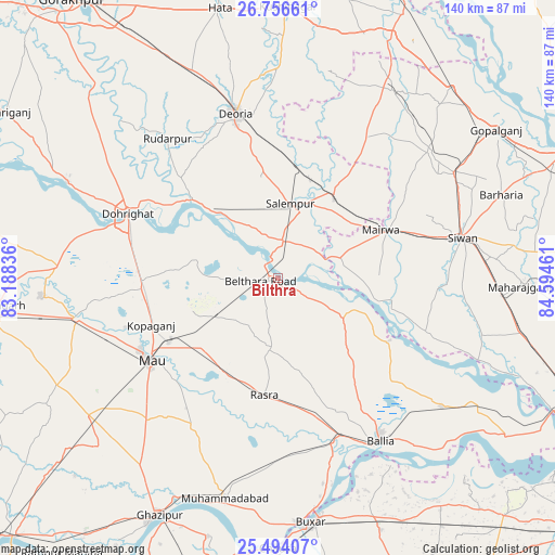
Bilthra GPS coordinates[2]
26° 7' 37.38" North, 83° 53' 29.328" East
| Map corner | latitude | longitude |
|---|---|---|
| Upper-left | 26.75661°, | 83.18836° |
| Center: | 26.12705°, | 83.89148° |
| Lower-right: | 25.49407°, | 84.59461° |
| Map W x H: | 140.4×140.4 km | = 87.2×87.2mi |
| max Lat: | 34.9274° ⇑28.6% North |
| Bilthra: | 26.12705° |
| min Lat: | ⇓71.4% South 8.09008° |
| min Long | Bilthra | max Long |
| 68.82655° | 83.89148° | 96.81° |
| W 81.7%⇐ | ⇒18.3% E |
Elevation
Elevation of Bilthra is 71 m = 233 ft, and this is 224.6 m = 737 ft below average elevation for this country.
| Max E: |
3681 m = 12077 ft | 74.4% |
| Avg. | 295.6 m = 970 ft | |
| Bilthra | 71 m = 233 ft | |
Min E: |
1 m = 3 ft | 25.6% |
See also: India elevation on elevation.city.
Geographical zone
Bilthra is located in North temperate zone (between Tropic of Cancer and the Arctic Circle). Distance of this Northern Tropic circle is 299.1 km =185.9 mi to South.| Distance of | km | miles | from Bilthra |
|---|---|---|---|
| North Pole | 7102 | 4413 | to North |
| Arctic Circle | 4496.1 | 2793.7 | to North |
| Tropic Cancer | 299.1 | 185.9 | to South |
| Equator | 2905.1 | 1805.1 | to South |


Nearby cities:
15 places around Bilthra: (largest is in red/bold)
• Bānsdīh
42.4 km =26.3 mi,  129°
129°
• Chillupār
42.1 km =26.2 mi,  294°
294°
• Deoria
43.1 km =26.8 mi,  344°
344°
• Dohrighāt
41.4 km =25.7 mi, 292°
• Ghosī
35.2 km =21.9 mi,  266°
266°
• Kopāganj
34.6 km =21.5 mi,  249°
249°
• Lar
11.5 km =7.1 mi,  42°
42°
• Mairwa
29.6 km =18.4 mi,  66°
66°
• Maniar
32.2 km =20 mi,  119°
119°
• Mau
38.9 km =24.2 mi,  238°
238°
• Muhammadābād
52 km =32.3 mi,  258°
258°
• Rasrā
30.2 km =18.8 mi,  186°
186°
• Rūdarpur
44.9 km =27.9 mi,  321°
321°
• Sikandarpur
18.6 km =11.6 mi, 120°
• Siwān
47.5 km =29.5 mi,  77°
77°
Sources, notices
• [Note1] Compared only with cities in India existing in our database
• [Src1] Map data: © OpenStreetMap contributors (CC-BY-SA)
• [Src2] Other city data from geonames.org with taken over terms of usage.
• [Src3] Geographical zone / Annual Mean Temperature by Robert A. Rohde @ Wikipedia
