Malpe geodata
Malpe (Karnataka) is a populated place; located in India in Asia/Kolkata (GMT+5.5) time zone. With population of 23,496 people, there are 1801 cities with bigger population in this country. Compared to other cities in India, 84.7% of cities are located further ↑North; 85.3% of cities are located further →East and 94.3% of cities have higher elevation than Malpe. Note1


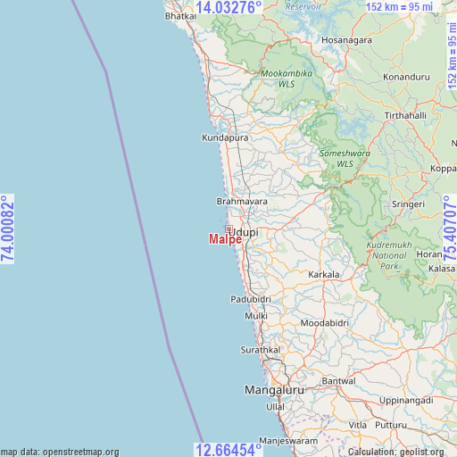
Malpe GPS coordinates[2]
13° 20' 58.632" North, 74° 42' 14.184" East
| Map corner | latitude | longitude |
|---|---|---|
| Upper-left | 14.03276°, | 74.00082° |
| Center: | 13.34962°, | 74.70394° |
| Lower-right: | 12.66454°, | 75.40707° |
| Map W x H: | 152.1×152.1 km | = 94.5×94.5mi |
| max Lat: | 34.9274° ⇑84.7% North |
| Malpe: | 13.34962° |
| min Lat: | ⇓15.3% South 8.09008° |
| min Long | Malpe | max Long |
| 68.82655° | 74.70394° | 96.81° |
| W 14.7%⇐ | ⇒85.3% E |
Elevation
Elevation of Malpe is 12 m = 39 ft, and this is 283.6 m = 930 ft below average elevation for this country.
| Max E: |
3681 m = 12077 ft | 94.3% |
| Avg. | 295.6 m = 970 ft | |
| Malpe | 12 m = 39 ft | |
Min E: |
1 m = 3 ft | 5.7% |
See also: India elevation on elevation.city.
Geographical zone
Malpe is located in North Torrid zone (between Equator and Tropic of Cancer). Distance of this Northern Tropic circle is 1121.6 km =696.9 mi to North.| Distance of | km | miles | from Malpe |
|---|---|---|---|
| North Pole | 8522.7 | 5295.8 | to North |
| Arctic Circle | 5916.8 | 3676.5 | to North |
| Tropic Cancer | 1121.6 | 696.9 | to North |
| Equator | 1484.3 | 922.3 | to South |


Nearby cities:
15 places around Malpe: (largest is in red/bold)
• Bantvāl
62.4 km =38.8 mi,  144°
144°
• Byndoor
58 km =36 mi,  352°
352°
• Coondapoor
31.4 km =19.5 mi,  357°
357°
• Gangolli
33.6 km =20.9 mi, 353°
• Hosangadi
47.2 km =29.3 mi,  34°
34°
• Kārkala
34.6 km =21.5 mi,  115°
115°
• Mangalore
50.8 km =31.6 mi,  161°
161°
• Manipal
8.6 km =5.3 mi,  89°
89°
• Mūdbidri
44.6 km =27.7 mi,  134°
134°
• Mūlki
30.3 km =18.8 mi, 161°
• Pāngāla
12.1 km =7.5 mi, 155°
• Someshwar
42.2 km =26.2 mi,  68°
68°
• Sringeri
59.8 km =37.2 mi,  82°
82°
• Udupi
4.9 km =3 mi,  109°
109°
• Ullal
62.8 km =39 mi, 164°
Sources, notices
• [Note1] Compared only with cities in India existing in our database
• [Src1] Map data: © OpenStreetMap contributors (CC-BY-SA)
• [Src2] Other city data from geonames.org with taken over terms of usage.
• [Src3] Geographical zone / Annual Mean Temperature by Robert A. Rohde @ Wikipedia
