Someshwar geodata
Someshwar (Karnataka) is a populated place; located in India in Asia/Kolkata (GMT+5.5) time zone. With population of 22,137 people, there are 1895 cities with bigger population in this country. Compared to other cities in India, 84.4% of cities are located further ↑North; 82.1% of cities are located further →East and 62.7% of cities have higher elevation than Someshwar. Note1


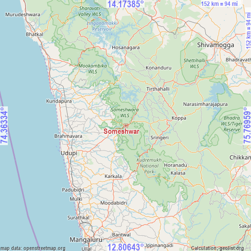
Someshwar GPS coordinates[2]
13° 29' 28.032" North, 75° 3' 59.256" East
| Map corner | latitude | longitude |
|---|---|---|
| Upper-left | 14.17385°, | 74.36334° |
| Center: | 13.49112°, | 75.06646° |
| Lower-right: | 12.80643°, | 75.76959° |
| Map W x H: | 152×152 km | = 94.4×94.4mi |
| max Lat: | 34.9274° ⇑84.4% North |
| Someshwar: | 13.49112° |
| min Lat: | ⇓15.6% South 8.09008° |
| min Long | Someshwar | max Long |
| 68.82655° | 75.06646° | 96.81° |
| W 17.9%⇐ | ⇒82.1% E |
Elevation
Elevation of Someshwar is 134 m = 440 ft, and this is 161.6 m = 530 ft below average elevation for this country.
| Max E: |
3681 m = 12077 ft | 62.7% |
| Avg. | 295.6 m = 970 ft | |
| Someshwar | 134 m = 440 ft | |
Min E: |
1 m = 3 ft | 37.3% |
See also: India elevation on elevation.city.
Geographical zone
Someshwar is located in North Torrid zone (between Equator and Tropic of Cancer). Distance of this Northern Tropic circle is 1105.8 km =687.1 mi to North.| Distance of | km | miles | from Someshwar |
|---|---|---|---|
| North Pole | 8507 | 5286 | to North |
| Arctic Circle | 5901.1 | 3666.8 | to North |
| Tropic Cancer | 1105.8 | 687.1 | to North |
| Equator | 1500.1 | 932.1 | to South |


Nearby cities:
15 places around Someshwar: (largest is in red/bold)
• Coondapoor
43.6 km =27.1 mi,  290°
290°
• Gangolli
46.3 km =28.8 mi, 292°
• Hosanagara
47 km =29.2 mi,  359°
359°
• Hosangadi
26 km =16.2 mi,  332°
332°
• Koppa
32.4 km =20.1 mi,  82°
82°
• Kārkala
31.8 km =19.8 mi,  194°
194°
• Malpe
42.2 km =26.2 mi,  248°
248°
• Manipal
34.4 km =21.4 mi,  242°
242°
• Mūdbidri
47.8 km =29.7 mi, 189°
• Mūlki
53.4 km =33.2 mi,  213°
213°
• Narasimharājapura
50 km =31.1 mi,  74°
74°
• Pāngāla
43.5 km =27 mi,  231°
231°
• Sringeri
21.8 km =13.5 mi,  112°
112°
• Tīrthahalli
29.2 km =18.1 mi,  41°
41°
• Udupi
38.8 km =24.1 mi, 243°
Sources, notices
• [Note1] Compared only with cities in India existing in our database
• [Src1] Map data: © OpenStreetMap contributors (CC-BY-SA)
• [Src2] Other city data from geonames.org with taken over terms of usage.
• [Src3] Geographical zone / Annual Mean Temperature by Robert A. Rohde @ Wikipedia
