Mūlki geodata
Mūlki (Karnataka) is a populated place; located in India in Asia/Kolkata (GMT+5.5) time zone. With population of 17,259 people, there are 2263 cities with bigger population in this country. Compared to other cities in India, 85.9% of cities are located further ↑North; 84.4% of cities are located further →East and 86.4% of cities have higher elevation than Mūlki. Note1


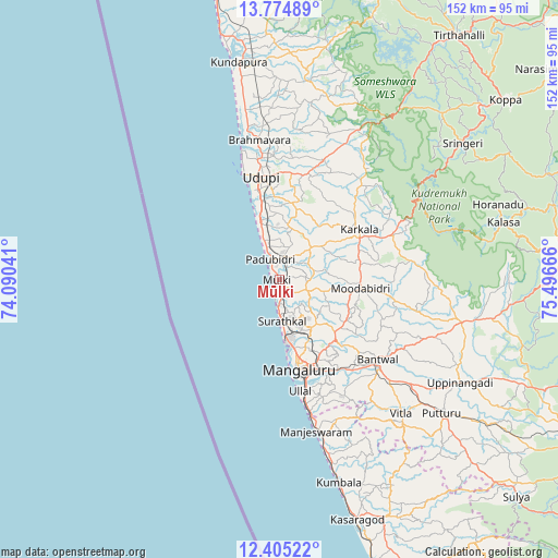
Mūlki GPS coordinates[2]
13° 5' 27.636" North, 74° 47' 36.708" East
| Map corner | latitude | longitude |
|---|---|---|
| Upper-left | 13.77489°, | 74.09041° |
| Center: | 13.09101°, | 74.79353° |
| Lower-right: | 12.40522°, | 75.49666° |
| Map W x H: | 152.3×152.3 km | = 94.6×94.6mi |
| max Lat: | 34.9274° ⇑85.9% North |
| Mūlki: | 13.09101° |
| min Lat: | ⇓14.1% South 8.09008° |
| min Long | Mūlki | max Long |
| 68.82655° | 74.79353° | 96.81° |
| W 15.6%⇐ | ⇒84.4% E |
Elevation
Elevation of Mūlki is 26 m = 85 ft, and this is 269.6 m = 885 ft below average elevation for this country.
| Max E: |
3681 m = 12077 ft | 86.4% |
| Avg. | 295.6 m = 970 ft | |
| Mūlki | 26 m = 85 ft | |
Min E: |
1 m = 3 ft | 13.6% |
See also: India elevation on elevation.city.
Geographical zone
Mūlki is located in North Torrid zone (between Equator and Tropic of Cancer). Distance of this Northern Tropic circle is 1150.3 km =714.8 mi to North.| Distance of | km | miles | from Mūlki |
|---|---|---|---|
| North Pole | 8551.5 | 5313.7 | to North |
| Arctic Circle | 5945.6 | 3694.4 | to North |
| Tropic Cancer | 1150.3 | 714.8 | to North |
| Equator | 1455.6 | 904.5 | to South |


Nearby cities:
15 places around Mūlki: (largest is in red/bold)
• Bantvāl
34.4 km =21.4 mi,  130°
130°
• Coondapoor
61.1 km =38 mi,  349°
349°
• Gangolli
63.6 km =39.5 mi, 347°
• Kārkala
25.5 km =15.8 mi,  57°
57°
• Malpe
30.3 km =18.8 mi,  341°
341°
• Mangalore
20.5 km =12.7 mi,  160°
160°
• Manipal
28.8 km =17.9 mi,  357°
357°
• Manjēshvar
43.3 km =26.9 mi,  166°
166°
• Mūdbidri
22 km =13.7 mi,  97°
97°
• Puttūr
57.6 km =35.8 mi, 129°
• Pāngāla
18.3 km =11.4 mi, 345°
• Someshwar
53.4 km =33.2 mi,  33°
33°
• Sringeri
61.5 km =38.2 mi,  53°
53°
• Udupi
27.6 km =17.1 mi, 349°
• Ullal
32.5 km =20.2 mi, 167°
Sources, notices
• [Note1] Compared only with cities in India existing in our database
• [Src1] Map data: © OpenStreetMap contributors (CC-BY-SA)
• [Src2] Other city data from geonames.org with taken over terms of usage.
• [Src3] Geographical zone / Annual Mean Temperature by Robert A. Rohde @ Wikipedia
