Kulti geodata
Kulti (West Bengal) is a populated place; located in India in Asia/Kolkata (GMT+5.5) time zone. With population of 305,405 people, there are 142 cities with bigger population in this country. Compared to other cities in India, 56.3% of cities are located further ↓South; 89% of cities are located further ←West and 58.4% of cities have higher elevation than Kulti. Note1


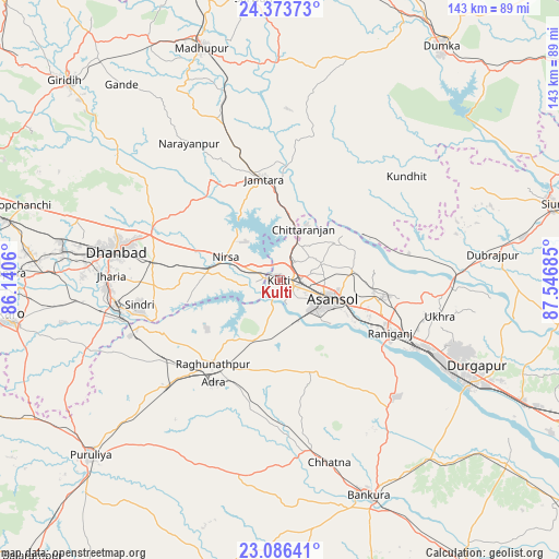
Kulti GPS coordinates[2]
23° 43' 53.976" North, 86° 50' 37.392" East
| Map corner | latitude | longitude |
|---|---|---|
| Upper-left | 24.37373°, | 86.1406° |
| Center: | 23.73166°, | 86.84372° |
| Lower-right: | 23.08641°, | 87.54685° |
| Map W x H: | 143.1×143.1 km | = 88.9×88.9mi |
| max Lat: | 34.9274° ⇑43.7% North |
| Kulti: | 23.73166° |
| min Lat: | ⇓56.3% South 8.09008° |
| min Long | Kulti | max Long |
| 68.82655° | 86.84372° | 96.81° |
| W 89%⇐ | ⇒11% E |
Elevation
Elevation of Kulti is 156 m = 512 ft, and this is 139.6 m = 458 ft below average elevation for this country.
| Max E: |
3681 m = 12077 ft | 58.4% |
| Avg. | 295.6 m = 970 ft | |
| Kulti | 156 m = 512 ft | |
Min E: |
1 m = 3 ft | 41.6% |
See also: Kulti elevation on elevation.city.
Geographical zone
Kulti is located in North temperate zone (between Tropic of Cancer and the Arctic Circle). Distance of this Northern Tropic circle is 32.8 km =20.4 mi to South.| Distance of | km | miles | from Kulti |
|---|---|---|---|
| North Pole | 7368.3 | 4578.4 | to North |
| Arctic Circle | 4762.5 | 2959.3 | to North |
| Tropic Cancer | 32.8 | 20.4 | to South |
| Equator | 2638.7 | 1639.6 | to South |


Nearby cities:
15 places around Kulti: (largest is in red/bold)
• Adra
30.8 km =19.1 mi,  211°
211°
• Bahula
33.9 km =21.1 mi,  105°
105°
• Bhojudih
42.3 km =26.3 mi,  255°
255°
• Chittaranjan
15.2 km =9.4 mi,  23°
23°
• Dhanbād
41.5 km =25.8 mi,  280°
280°
• Gobindpur
35 km =21.7 mi,  289°
289°
• Jāmtāra
26.1 km =16.2 mi,  350°
350°
• Jāmuria
24.1 km =15 mi,  97°
97°
• Lakhyabad
19.4 km =12.1 mi,  248°
248°
• Mugma
12.6 km =7.8 mi, 289°
• Nirsā
15.1 km =9.4 mi, 292°
• Pāthardih
42.6 km =26.5 mi, 260°
• Raghunathpur
27.6 km =17.1 mi,  218°
218°
• Rānīganj
31.9 km =19.8 mi, 113°
• Āsansol
15.2 km =9.4 mi, 110°
Sources, notices
• [Note1] Compared only with cities in India existing in our database
• [Src1] Map data: © OpenStreetMap contributors (CC-BY-SA)
• [Src2] Other city data from geonames.org with taken over terms of usage.
• [Src3] Geographical zone / Annual Mean Temperature by Robert A. Rohde @ Wikipedia
