Āsansol geodata
Āsansol (West Bengal) is a seat of a second-order administrative division; located in India in Asia/Kolkata (GMT+5.5) time zone. With population of 504,271 people, there are 90 cities with bigger population in this country. Compared to other cities in India, 55.9% of cities are located further ↓South; 89.2% of cities are located further ←West and 65.2% of cities have higher elevation than Āsansol. Note1


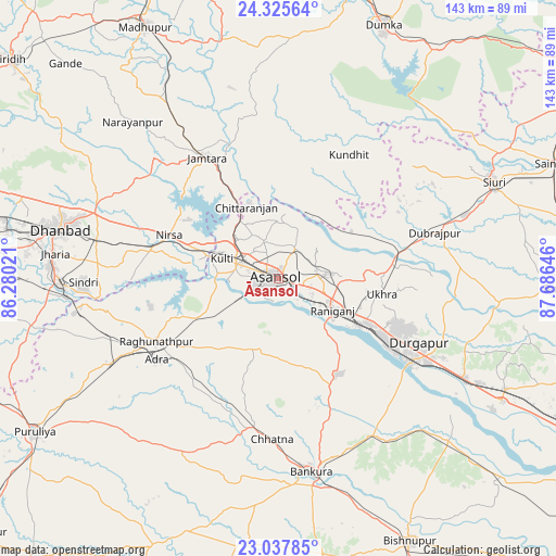
Āsansol GPS coordinates[2]
23° 40' 59.988" North, 86° 58' 59.988" East
| Map corner | latitude | longitude |
|---|---|---|
| Upper-left | 24.32564°, | 86.28021° |
| Center: | 23.68333°, | 86.98333° |
| Lower-right: | 23.03785°, | 87.68646° |
| Map W x H: | 143.2×143.2 km | = 89×89mi |
| max Lat: | 34.9274° ⇑44.1% North |
| Āsansol: | 23.68333° |
| min Lat: | ⇓55.9% South 8.09008° |
| min Long | Āsansol | max Long |
| 68.82655° | 86.98333° | 96.81° |
| W 89.2%⇐ | ⇒10.8% E |
Elevation
Elevation of Āsansol is 119 m = 390 ft, and this is 176.6 m = 579 ft below average elevation for this country.
| Max E: |
3681 m = 12077 ft | 65.2% |
| Avg. | 295.6 m = 970 ft | |
| Āsansol | 119 m = 390 ft | |
Min E: |
1 m = 3 ft | 34.8% |
See also: Āsansol elevation on elevation.city.
Geographical zone
Āsansol is located in North temperate zone (between Tropic of Cancer and the Arctic Circle). Distance of this Northern Tropic circle is 27.4 km =17 mi to South.| Distance of | km | miles | from Āsansol |
|---|---|---|---|
| North Pole | 7373.7 | 4581.8 | to North |
| Arctic Circle | 4767.8 | 2962.6 | to North |
| Tropic Cancer | 27.4 | 17 | to South |
| Equator | 2633.3 | 1636.3 | to South |


Nearby cities:
15 places around Āsansol: (largest is in red/bold)
• Adra
36.9 km =22.9 mi,  235°
235°
• Bahula
18.8 km =11.7 mi,  100°
100°
• Bakreswar
45.4 km =28.2 mi,  60°
60°
• Barjora
42.3 km =26.3 mi,  132°
132°
• Chittaranjan
20.9 km =13 mi,  337°
337°
• Dubrājpur
41.7 km =25.9 mi,  73°
73°
• Durgapur
38 km =23.6 mi,  119°
119°
• Jāmtāra
36.1 km =22.4 mi,  329°
329°
• Jāmuria
10 km =6.2 mi,  76°
76°
• Kulti
15.2 km =9.4 mi,  290°
290°
• Lakhyabad
32.3 km =20.1 mi,  266°
266°
• Mugma
27.8 km =17.3 mi, 290°
• Nirsā
30.3 km =18.8 mi, 291°
• Raghunathpur
35.4 km =22 mi, 243°
• Rānīganj
16.7 km =10.4 mi, 116°
Sources, notices
• [Note1] Compared only with cities in India existing in our database
• [Src1] Map data: © OpenStreetMap contributors (CC-BY-SA)
• [Src2] Other city data from geonames.org with taken over terms of usage.
• [Src3] Geographical zone / Annual Mean Temperature by Robert A. Rohde @ Wikipedia
