Tāsgaon geodata
Tāsgaon (Maharashtra) is a populated place; located in India in Asia/Kolkata (GMT+5.5) time zone. With population of 34,933 people, there are 1246 cities with bigger population in this country. Compared to other cities in India, 74.7% of cities are located further ↑North; 86% of cities are located further →East and 87.5% of cities have lower elevation than Tāsgaon. Note1


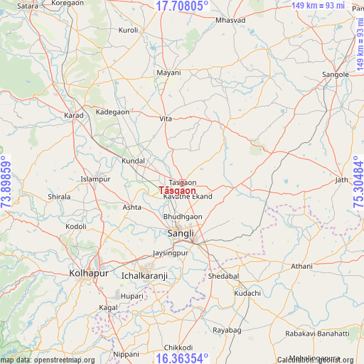
Tāsgaon GPS coordinates[2]
17° 2' 13.2" North, 74° 36' 6.156" East
| Map corner | latitude | longitude |
|---|---|---|
| Upper-left | 17.70805°, | 73.89859° |
| Center: | 17.037°, | 74.60171° |
| Lower-right: | 16.36354°, | 75.30484° |
| Map W x H: | 149.5×149.5 km | = 92.9×92.9mi |
| max Lat: | 34.9274° ⇑74.7% North |
| Tāsgaon: | 17.037° |
| min Lat: | ⇓25.3% South 8.09008° |
| min Long | Tāsgaon | max Long |
| 68.82655° | 74.60171° | 96.81° |
| W 14%⇐ | ⇒86% E |
Elevation
Elevation of Tāsgaon is 586 m = 1923 ft, and this is 290.4 m = 953 ft above average elevation for this country.
| Max E: |
3681 m = 12077 ft | 12.5% |
| Tāsgaon | 586 m 1923 ft | |
| Avg. | 295.6 m = 970 ft | |
Min E: |
1 m = 3 ft | 87.5% |
See also: India elevation on elevation.city.
Geographical zone
Tāsgaon is located in North Torrid zone (between Equator and Tropic of Cancer). Distance of this Northern Tropic circle is 711.6 km =442.2 mi to North.| Distance of | km | miles | from Tāsgaon |
|---|---|---|---|
| North Pole | 8112.7 | 5041 | to North |
| Arctic Circle | 5506.8 | 3421.8 | to North |
| Tropic Cancer | 711.6 | 442.2 | to North |
| Equator | 1894.3 | 1177.1 | to South |


Nearby cities:
15 places around Tāsgaon: (largest is in red/bold)
• Ashta
22.7 km =14.1 mi,  244°
244°
• Bhudgaon
14.4 km =8.9 mi,  180°
180°
• Ichalkaranji
41.3 km =25.7 mi,  201°
201°
• Jaisingpur
29.4 km =18.3 mi,  190°
190°
• Karād
52.7 km =32.7 mi,  302°
302°
• Kodoli
47.2 km =29.3 mi,  247°
247°
• Kolhāpur
54.7 km =34 mi,  226°
226°
• Kudachi
52.8 km =32.8 mi,  149°
149°
• Kurandvād
39.4 km =24.5 mi, 181°
• Malkapur
51.7 km =32.1 mi, 298°
• Panhāla
58 km =36 mi, 244°
• Sadalgi
53.7 km =33.4 mi, 187°
• Shiraguppi
47.9 km =29.8 mi,  166°
166°
• Sāngli
20.7 km =12.9 mi, 191°
• Vite
27.1 km =16.8 mi,  345°
345°
Sources, notices
• [Note1] Compared only with cities in India existing in our database
• [Src1] Map data: © OpenStreetMap contributors (CC-BY-SA)
• [Src2] Other city data from geonames.org with taken over terms of usage.
• [Src3] Geographical zone / Annual Mean Temperature by Robert A. Rohde @ Wikipedia
