Kundgol geodata
Kundgol (Karnataka) is a populated place; located in India in Asia/Kolkata (GMT+5.5) time zone. With population of 17,617 people, there are 2226 cities with bigger population in this country. Compared to other cities in India, 81.1% of cities are located further ↑North; 80.6% of cities are located further →East and 90.5% of cities have lower elevation than Kundgol. Note1


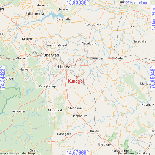
Kundgol GPS coordinates[2]
15° 15' 22.032" North, 75° 14' 50.46" East
| Map corner | latitude | longitude |
|---|---|---|
| Upper-left | 15.93336°, | 74.54423° |
| Center: | 15.25612°, | 75.24735° |
| Lower-right: | 14.57669°, | 75.95048° |
| Map W x H: | 150.8×150.8 km | = 93.7×93.7mi |
| max Lat: | 34.9274° ⇑81.1% North |
| Kundgol: | 15.25612° |
| min Lat: | ⇓18.9% South 8.09008° |
| min Long | Kundgol | max Long |
| 68.82655° | 75.24735° | 96.81° |
| W 19.4%⇐ | ⇒80.6% E |
Elevation
Elevation of Kundgol is 645 m = 2116 ft, and this is 349.4 m = 1146 ft above average elevation for this country.
| Max E: |
3681 m = 12077 ft | 9.5% |
| Kundgol | 645 m 2116 ft | |
| Avg. | 295.6 m = 970 ft | |
Min E: |
1 m = 3 ft | 90.5% |
See also: India elevation on elevation.city.
Geographical zone
Kundgol is located in North Torrid zone (between Equator and Tropic of Cancer). Distance of this Northern Tropic circle is 909.6 km =565.2 mi to North.| Distance of | km | miles | from Kundgol |
|---|---|---|---|
| North Pole | 8310.7 | 5164 | to North |
| Arctic Circle | 5704.9 | 3544.9 | to North |
| Tropic Cancer | 909.6 | 565.2 | to North |
| Equator | 1696.3 | 1054 | to South |


Nearby cities:
15 places around Kundgol: (largest is in red/bold)
• Annigeri
27.4 km =17 mi,  46°
46°
• Gadag
45.3 km =28.1 mi,  64°
64°
• Gadag-Betageri
43.4 km =27 mi,  65°
65°
• Haliyal
53.3 km =33.1 mi,  278°
278°
• Hubli
15.9 km =9.9 mi,  309°
309°
• Hāveri
54.1 km =33.6 mi,  161°
161°
• Kalghatgi
30.7 km =19.1 mi,  254°
254°
• Lakshmeshwar
27.8 km =17.3 mi,  121°
121°
• Mulgund
29.5 km =18.3 mi,  84°
84°
• Mundgod
38.9 km =24.2 mi,  215°
215°
• Nargund
54 km =33.6 mi,  16°
16°
• Navalgund
35.5 km =22.1 mi, 18°
• Savanūr
32.9 km =20.4 mi, 162°
• Shiggaon
29.6 km =18.4 mi,  184°
184°
• Shirhatti
35.8 km =22.2 mi,  94°
94°
Sources, notices
• [Note1] Compared only with cities in India existing in our database
• [Src1] Map data: © OpenStreetMap contributors (CC-BY-SA)
• [Src2] Other city data from geonames.org with taken over terms of usage.
• [Src3] Geographical zone / Annual Mean Temperature by Robert A. Rohde @ Wikipedia
