Kalghatgi geodata
Kalghatgi (Karnataka) is a populated place; located in India in Asia/Kolkata (GMT+5.5) time zone. With population of 15,428 people, there are 2420 cities with bigger population in this country. Compared to other cities in India, 81.3% of cities are located further ↑North; 83% of cities are located further →East and 86.5% of cities have lower elevation than Kalghatgi. Note1


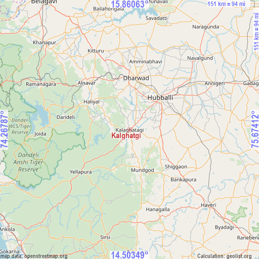
Kalghatgi GPS coordinates[2]
15° 10' 59.34" North, 74° 58' 15.564" East
| Map corner | latitude | longitude |
|---|---|---|
| Upper-left | 15.86063°, | 74.26787° |
| Center: | 15.18315°, | 74.97099° |
| Lower-right: | 14.50349°, | 75.67412° |
| Map W x H: | 150.9×150.9 km | = 93.8×93.8mi |
| max Lat: | 34.9274° ⇑81.3% North |
| Kalghatgi: | 15.18315° |
| min Lat: | ⇓18.7% South 8.09008° |
| min Long | Kalghatgi | max Long |
| 68.82655° | 74.97099° | 96.81° |
| W 17%⇐ | ⇒83% E |
Elevation
Elevation of Kalghatgi is 568 m = 1864 ft, and this is 272.4 m = 894 ft above average elevation for this country.
| Max E: |
3681 m = 12077 ft | 13.5% |
| Kalghatgi | 568 m 1864 ft | |
| Avg. | 295.6 m = 970 ft | |
Min E: |
1 m = 3 ft | 86.5% |
See also: India elevation on elevation.city.
Geographical zone
Kalghatgi is located in North Torrid zone (between Equator and Tropic of Cancer). Distance of this Northern Tropic circle is 917.7 km =570.2 mi to North.| Distance of | km | miles | from Kalghatgi |
|---|---|---|---|
| North Pole | 8318.9 | 5169.1 | to North |
| Arctic Circle | 5713 | 3549.9 | to North |
| Tropic Cancer | 917.7 | 570.2 | to North |
| Equator | 1688.2 | 1049 | to South |


Nearby cities:
15 places around Kalghatgi: (largest is in red/bold)
• Alnāvar
36.7 km =22.8 mi,  317°
317°
• Annigeri
56.4 km =35 mi,  61°
61°
• Dandeli
39.1 km =24.3 mi,  283°
283°
• Haliyal
28.1 km =17.5 mi,  305°
305°
• Hubli
25.3 km =15.7 mi,  43°
43°
• Hāngal
49.4 km =30.7 mi,  160°
160°
• Kundgol
30.7 km =19.1 mi,  74°
74°
• Lakshmeshwar
53.8 km =33.4 mi,  96°
96°
• Londa
58 km =36 mi,  303°
303°
• Mulgund
60 km =37.3 mi,  79°
79°
• Mundgod
24.6 km =15.3 mi, 163°
• Navalgund
58.5 km =36.4 mi, 44°
• Savanūr
45.7 km =28.4 mi,  120°
120°
• Shiggaon
34.7 km =21.6 mi,  128°
128°
• Yellāpur
37.2 km =23.1 mi,  229°
229°
Sources, notices
• [Note1] Compared only with cities in India existing in our database
• [Src1] Map data: © OpenStreetMap contributors (CC-BY-SA)
• [Src2] Other city data from geonames.org with taken over terms of usage.
• [Src3] Geographical zone / Annual Mean Temperature by Robert A. Rohde @ Wikipedia
