Nargund geodata
Nargund (Karnataka) is a populated place; located in India in Asia/Kolkata (GMT+5.5) time zone. With population of 33,403 people, there are 1302 cities with bigger population in this country. Compared to other cities in India, 78.9% of cities are located further ↑North; 79.3% of cities are located further →East and 88.7% of cities have lower elevation than Nargund. Note1


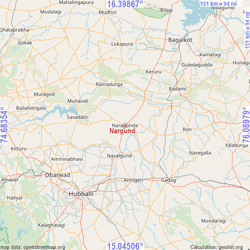
Nargund GPS coordinates[2]
15° 43' 22.764" North, 75° 23' 11.976" East
| Map corner | latitude | longitude |
|---|---|---|
| Upper-left | 16.39867°, | 74.68354° |
| Center: | 15.72299°, | 75.38666° |
| Lower-right: | 15.04506°, | 76.08979° |
| Map W x H: | 150.5×150.5 km | = 93.5×93.5mi |
| max Lat: | 34.9274° ⇑78.9% North |
| Nargund: | 15.72299° |
| min Lat: | ⇓21.1% South 8.09008° |
| min Long | Nargund | max Long |
| 68.82655° | 75.38666° | 96.81° |
| W 20.7%⇐ | ⇒79.3% E |
Elevation
Elevation of Nargund is 606 m = 1988 ft, and this is 310.4 m = 1018 ft above average elevation for this country.
| Max E: |
3681 m = 12077 ft | 11.3% |
| Nargund | 606 m 1988 ft | |
| Avg. | 295.6 m = 970 ft | |
Min E: |
1 m = 3 ft | 88.7% |
See also: India elevation on elevation.city.
Geographical zone
Nargund is located in North Torrid zone (between Equator and Tropic of Cancer). Distance of this Northern Tropic circle is 857.7 km =532.9 mi to North.| Distance of | km | miles | from Nargund |
|---|---|---|---|
| North Pole | 8258.8 | 5131.8 | to North |
| Arctic Circle | 5652.9 | 3512.5 | to North |
| Tropic Cancer | 857.7 | 532.9 | to North |
| Equator | 1748.2 | 1086.3 | to South |


Nearby cities:
15 places around Nargund: (largest is in red/bold)
• Annigeri
33.5 km =20.8 mi,  171°
171°
• Bail-Hongal
57.4 km =35.7 mi,  280°
280°
• Bādāmi
37.7 km =23.4 mi,  55°
55°
• Gadag
41.7 km =25.9 mi,  141°
141°
• Gadag-Betageri
42 km =26.1 mi, 144°
• Guledagudda
56.4 km =35 mi,  49°
49°
• Hubli
49.7 km =30.9 mi,  212°
212°
• Kerūr
36.6 km =22.7 mi,  27°
27°
• Kundgol
54 km =33.6 mi,  196°
196°
• Mulgund
51.3 km =31.9 mi,  163°
163°
• Naregal
48.1 km =29.9 mi,  110°
110°
• Navalgund
18.6 km =11.6 mi,  191°
191°
• Ron
37.3 km =23.2 mi,  94°
94°
• Saundatti
29.2 km =18.1 mi, 279°
• Shirhatti
58.2 km =36.2 mi, 159°
Sources, notices
• [Note1] Compared only with cities in India existing in our database
• [Src1] Map data: © OpenStreetMap contributors (CC-BY-SA)
• [Src2] Other city data from geonames.org with taken over terms of usage.
• [Src3] Geographical zone / Annual Mean Temperature by Robert A. Rohde @ Wikipedia
