Shiggaon geodata
Shiggaon (Karnataka) is a populated place; located in India in Asia/Kolkata (GMT+5.5) time zone. With population of 26,118 people, there are 1634 cities with bigger population in this country. Compared to other cities in India, 81.6% of cities are located further ↑North; 80.8% of cities are located further →East and 89.3% of cities have lower elevation than Shiggaon. Note1


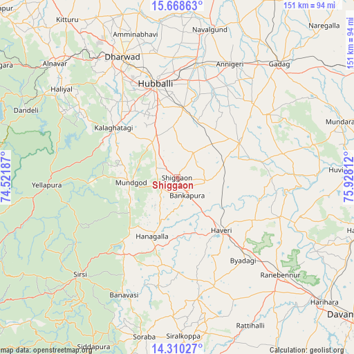
Shiggaon GPS coordinates[2]
14° 59' 25.908" North, 75° 13' 29.964" East
| Map corner | latitude | longitude |
|---|---|---|
| Upper-left | 15.66863°, | 74.52187° |
| Center: | 14.99053°, | 75.22499° |
| Lower-right: | 14.31027°, | 75.92812° |
| Map W x H: | 151×151 km | = 93.8×93.8mi |
| max Lat: | 34.9274° ⇑81.6% North |
| Shiggaon: | 14.99053° |
| min Lat: | ⇓18.4% South 8.09008° |
| min Long | Shiggaon | max Long |
| 68.82655° | 75.22499° | 96.81° |
| W 19.2%⇐ | ⇒80.8% E |
Elevation
Elevation of Shiggaon is 621 m = 2037 ft, and this is 325.4 m = 1068 ft above average elevation for this country.
| Max E: |
3681 m = 12077 ft | 10.7% |
| Shiggaon | 621 m 2037 ft | |
| Avg. | 295.6 m = 970 ft | |
Min E: |
1 m = 3 ft | 89.3% |
See also: India elevation on elevation.city.
Geographical zone
Shiggaon is located in North Torrid zone (between Equator and Tropic of Cancer). Distance of this Northern Tropic circle is 939.1 km =583.5 mi to North.| Distance of | km | miles | from Shiggaon |
|---|---|---|---|
| North Pole | 8340.3 | 5182.4 | to North |
| Arctic Circle | 5734.4 | 3563.2 | to North |
| Tropic Cancer | 939.1 | 583.5 | to North |
| Equator | 1666.8 | 1035.7 | to South |


Nearby cities:
15 places around Shiggaon: (largest is in red/bold)
• Annigeri
53.3 km =33.1 mi,  24°
24°
• Byādgi
45.1 km =28 mi,  141°
141°
• Hubli
40.9 km =25.4 mi,  346°
346°
• Hāngal
27.3 km =17 mi,  203°
203°
• Hāveri
29.2 km =18.1 mi, 138°
• Kalghatgi
34.7 km =21.6 mi,  308°
308°
• Kundgol
29.6 km =18.4 mi,  4°
4°
• Lakshmeshwar
30.3 km =18.8 mi,  59°
59°
• Mulgund
45.3 km =28.1 mi,  44°
44°
• Mundgod
20.3 km =12.6 mi,  264°
264°
• Rānībennur
59.7 km =37.1 mi,  133°
133°
• Savanūr
12.2 km =7.6 mi,  99°
99°
• Shirhatti
46.7 km =29 mi,  54°
54°
• Sirsi
58.7 km =36.5 mi,  225°
225°
• Yellāpur
55.5 km =34.5 mi,  266°
266°
Sources, notices
• [Note1] Compared only with cities in India existing in our database
• [Src1] Map data: © OpenStreetMap contributors (CC-BY-SA)
• [Src2] Other city data from geonames.org with taken over terms of usage.
• [Src3] Geographical zone / Annual Mean Temperature by Robert A. Rohde @ Wikipedia
