Mundgod geodata
Mundgod (Karnataka) is a populated place; located in India in Asia/Kolkata (GMT+5.5) time zone. With population of 17,000 people, there are 2287 cities with bigger population in this country. Compared to other cities in India, 81.7% of cities are located further ↑North; 82.4% of cities are located further →East and 87.1% of cities have lower elevation than Mundgod. Note1


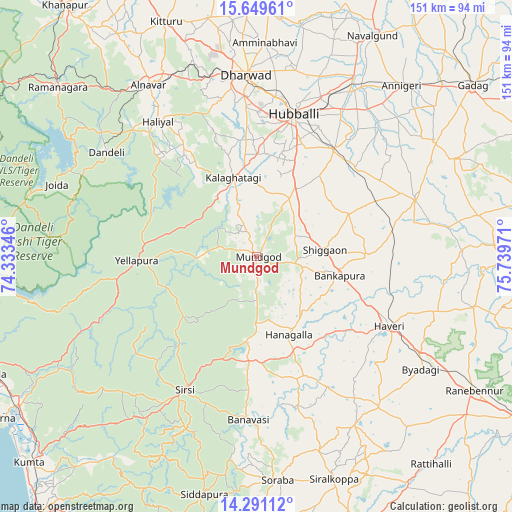
Mundgod GPS coordinates[2]
14° 58' 17.184" North, 75° 2' 11.688" East
| Map corner | latitude | longitude |
|---|---|---|
| Upper-left | 15.64961°, | 74.33346° |
| Center: | 14.97144°, | 75.03658° |
| Lower-right: | 14.29112°, | 75.73971° |
| Map W x H: | 151×151.1 km | = 93.8×93.9mi |
| max Lat: | 34.9274° ⇑81.7% North |
| Mundgod: | 14.97144° |
| min Lat: | ⇓18.3% South 8.09008° |
| min Long | Mundgod | max Long |
| 68.82655° | 75.03658° | 96.81° |
| W 17.6%⇐ | ⇒82.4% E |
Elevation
Elevation of Mundgod is 579 m = 1900 ft, and this is 283.4 m = 930 ft above average elevation for this country.
| Max E: |
3681 m = 12077 ft | 12.9% |
| Mundgod | 579 m 1900 ft | |
| Avg. | 295.6 m = 970 ft | |
Min E: |
1 m = 3 ft | 87.1% |
See also: India elevation on elevation.city.
Geographical zone
Mundgod is located in North Torrid zone (between Equator and Tropic of Cancer). Distance of this Northern Tropic circle is 941.3 km =584.9 mi to North.| Distance of | km | miles | from Mundgod |
|---|---|---|---|
| North Pole | 8342.4 | 5183.7 | to North |
| Arctic Circle | 5736.5 | 3564.5 | to North |
| Tropic Cancer | 941.3 | 584.9 | to North |
| Equator | 1664.7 | 1034.4 | to South |


Nearby cities:
15 places around Mundgod: (largest is in red/bold)
• Alnāvar
59.8 km =37.2 mi,  327°
327°
• Byādgi
58.7 km =36.5 mi,  124°
124°
• Dandeli
55.8 km =34.7 mi,  306°
306°
• Haliyal
49.8 km =30.9 mi,  322°
322°
• Hubli
43.1 km =26.8 mi,  13°
13°
• Hāngal
24.9 km =15.5 mi,  157°
157°
• Hāveri
44.2 km =27.5 mi, 116°
• Kalghatgi
24.6 km =15.3 mi,  343°
343°
• Kundgol
38.9 km =24.2 mi,  35°
35°
• Lakshmeshwar
49.6 km =30.8 mi,  69°
69°
• Mulgund
62.4 km =38.8 mi,  56°
56°
• Savanūr
32.3 km =20.1 mi,  89°
89°
• Shiggaon
20.3 km =12.6 mi,  84°
84°
• Sirsi
44.6 km =27.7 mi,  208°
208°
• Yellāpur
35.2 km =21.9 mi,  268°
268°
Sources, notices
• [Note1] Compared only with cities in India existing in our database
• [Src1] Map data: © OpenStreetMap contributors (CC-BY-SA)
• [Src2] Other city data from geonames.org with taken over terms of usage.
• [Src3] Geographical zone / Annual Mean Temperature by Robert A. Rohde @ Wikipedia
