Bājna geodata
Bājna (Uttar Pradesh) is a populated place; located in India in Asia/Kolkata (GMT+5.5) time zone. With population of 7,673 people, there are 3151 cities with bigger population in this country. Compared to other cities in India, 84% of cities are located further ↓South; 55.3% of cities are located further →East and 51.9% of cities have higher elevation than Bājna. Note1


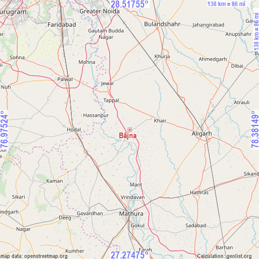
Bājna GPS coordinates[2]
27° 53' 52.548" North, 77° 40' 42.096" East
| Map corner | latitude | longitude |
|---|---|---|
| Upper-left | 28.51755°, | 76.97524° |
| Center: | 27.89793°, | 77.67836° |
| Lower-right: | 27.27475°, | 78.38149° |
| Map W x H: | 138.2×138.2 km | = 85.9×85.9mi |
| max Lat: | 34.9274° ⇑16% North |
| Bājna: | 27.89793° |
| min Lat: | ⇓84% South 8.09008° |
| min Long | Bājna | max Long |
| 68.82655° | 77.67836° | 96.81° |
| W 44.7%⇐ | ⇒55.3% E |
Elevation
Elevation of Bājna is 191 m = 627 ft, and this is 104.6 m = 343 ft below average elevation for this country.
| Max E: |
3681 m = 12077 ft | 51.9% |
| Avg. | 295.6 m = 970 ft | |
| Bājna | 191 m = 627 ft | |
Min E: |
1 m = 3 ft | 48.1% |
See also: India elevation on elevation.city.
Geographical zone
Bājna is located in North temperate zone (between Tropic of Cancer and the Arctic Circle). Distance of this Northern Tropic circle is 496 km =308.2 mi to South.| Distance of | km | miles | from Bājna |
|---|---|---|---|
| North Pole | 6905.1 | 4290.6 | to North |
| Arctic Circle | 4299.2 | 2671.4 | to North |
| Tropic Cancer | 496 | 308.2 | to South |
| Equator | 3102 | 1927.5 | to South |


Nearby cities:
15 places around Bājna: (largest is in red/bold)
• Alīgarh
39 km =24.2 mi,  92°
92°
• Barsāna
40.7 km =25.3 mi,  226°
226°
• Beswān
35.1 km =21.8 mi,  145°
145°
• Chhāta
25.6 km =15.9 mi,  220°
220°
• Hasanpur
19.6 km =12.2 mi,  293°
293°
• Hodal
30.6 km =19 mi,  268°
268°
• Iglās
33.1 km =20.6 mi,  128°
128°
• Jahāngīrpur
31.4 km =19.5 mi,  4°
4°
• Jewar
27.6 km =17.1 mi,  334°
334°
• Khair
16.8 km =10.4 mi,  73°
73°
• Kosi
26.4 km =16.4 mi,  244°
244°
• Nandgaon
35.4 km =22 mi, 234°
• Rabūpura
40 km =24.9 mi,  349°
349°
• Rāya
39.6 km =24.6 mi,  163°
163°
• Vrindāvan
35.3 km =21.9 mi,  177°
177°
Sources, notices
• [Note1] Compared only with cities in India existing in our database
• [Src1] Map data: © OpenStreetMap contributors (CC-BY-SA)
• [Src2] Other city data from geonames.org with taken over terms of usage.
• [Src3] Geographical zone / Annual Mean Temperature by Robert A. Rohde @ Wikipedia
