Palwal geodata
Palwal (Haryana) is a populated place; located in India in Asia/Kolkata (GMT+5.5) time zone. With population of 121,965 people, there are 360 cities with bigger population in this country. Compared to other cities in India, 85.1% of cities are located further ↓South; 59.3% of cities are located further →East and 50.1% of cities have lower elevation than Palwal. Note1


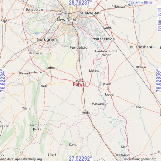
Palwal GPS coordinates[2]
28° 8' 40.884" North, 77° 19' 31.656" East
| Map corner | latitude | longitude |
|---|---|---|
| Upper-left | 28.76287°, | 76.62234° |
| Center: | 28.14469°, | 77.32546° |
| Lower-right: | 27.52292°, | 78.02859° |
| Map W x H: | 137.9×137.9 km | = 85.7×85.7mi |
| max Lat: | 34.9274° ⇑14.9% North |
| Palwal: | 28.14469° |
| min Lat: | ⇓85.1% South 8.09008° |
| min Long | Palwal | max Long |
| 68.82655° | 77.32546° | 96.81° |
| W 40.7%⇐ | ⇒59.3% E |
Elevation
Elevation of Palwal is 201 m = 659 ft, and this is 94.6 m = 310 ft below average elevation for this country.
| Max E: |
3681 m = 12077 ft | 49.9% |
| Avg. | 295.6 m = 970 ft | |
| Palwal | 201 m = 659 ft | |
Min E: |
1 m = 3 ft | 50.1% |
See also: Palwal elevation on elevation.city.
Geographical zone
Palwal is located in North temperate zone (between Tropic of Cancer and the Arctic Circle). Distance of this Northern Tropic circle is 523.5 km =325.3 mi to South.| Distance of | km | miles | from Palwal |
|---|---|---|---|
| North Pole | 6877.7 | 4273.6 | to North |
| Arctic Circle | 4271.8 | 2654.4 | to North |
| Tropic Cancer | 523.5 | 325.3 | to South |
| Equator | 3129.4 | 1944.5 | to South |


Nearby cities:
15 places around Palwal: (largest is in red/bold)
• Bīlāspur
40.1 km =24.9 mi,  46°
46°
• Dankaur
32.1 km =19.9 mi,  44°
44°
• Deoli
40.8 km =25.4 mi,  346°
346°
• Faridabad
29.7 km =18.5 mi,  357°
357°
• Greater Noida
44.2 km =27.5 mi,  27°
27°
• Hasanpur
25.6 km =15.9 mi,  139°
139°
• Hodal
28.4 km =17.6 mi,  171°
171°
• Jahāngīrpur
37.4 km =23.2 mi,  84°
84°
• Jewar
22.9 km =14.2 mi,  96°
96°
• Kosi
40.4 km =25.1 mi,  164°
164°
• Nūh
32.1 km =19.9 mi,  261°
261°
• Pūnāhāna
33.4 km =20.8 mi,  200°
200°
• Rabūpura
29.6 km =18.4 mi,  66°
66°
• Sohna
27.9 km =17.3 mi,  294°
294°
• Tāoru
37.6 km =23.4 mi,  281°
281°
Sources, notices
• [Note1] Compared only with cities in India existing in our database
• [Src1] Map data: © OpenStreetMap contributors (CC-BY-SA)
• [Src2] Other city data from geonames.org with taken over terms of usage.
• [Src3] Geographical zone / Annual Mean Temperature by Robert A. Rohde @ Wikipedia
