Hodal geodata
Hodal (Haryana) is a populated place; located in India in Asia/Kolkata (GMT+5.5) time zone. With population of 44,300 people, there are 999 cities with bigger population in this country. Compared to other cities in India, 84% of cities are located further ↓South; 58.6% of cities are located further →East and 50.5% of cities have higher elevation than Hodal. Note1


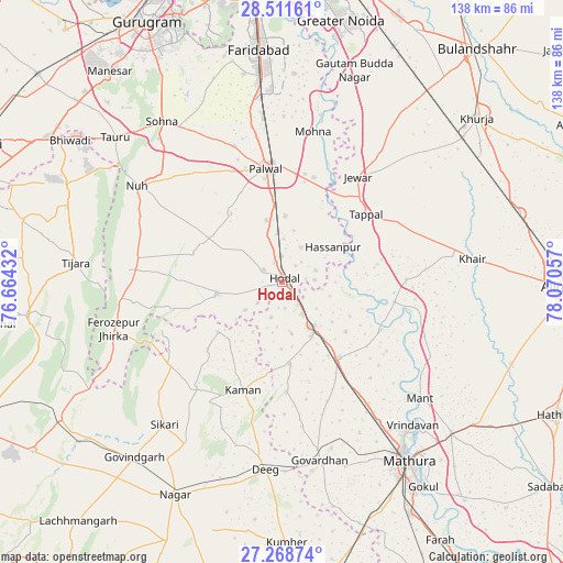
Hodal GPS coordinates[2]
27° 53' 31.056" North, 77° 22' 2.784" East
| Map corner | latitude | longitude |
|---|---|---|
| Upper-left | 28.51161°, | 76.66432° |
| Center: | 27.89196°, | 77.36744° |
| Lower-right: | 27.26874°, | 78.07057° |
| Map W x H: | 138.2×138.2 km | = 85.9×85.9mi |
| max Lat: | 34.9274° ⇑16% North |
| Hodal: | 27.89196° |
| min Lat: | ⇓84% South 8.09008° |
| min Long | Hodal | max Long |
| 68.82655° | 77.36744° | 96.81° |
| W 41.4%⇐ | ⇒58.6% E |
Elevation
Elevation of Hodal is 199 m = 653 ft, and this is 96.6 m = 317 ft below average elevation for this country.
| Max E: |
3681 m = 12077 ft | 50.5% |
| Avg. | 295.6 m = 970 ft | |
| Hodal | 199 m = 653 ft | |
Min E: |
1 m = 3 ft | 49.5% |
See also: Hodal elevation on elevation.city.
Geographical zone
Hodal is located in North temperate zone (between Tropic of Cancer and the Arctic Circle). Distance of this Northern Tropic circle is 495.4 km =307.8 mi to South.| Distance of | km | miles | from Hodal |
|---|---|---|---|
| North Pole | 6905.8 | 4291.1 | to North |
| Arctic Circle | 4299.9 | 2671.8 | to North |
| Tropic Cancer | 495.4 | 307.8 | to South |
| Equator | 3101.3 | 1927.1 | to South |


Nearby cities:
15 places around Hodal: (largest is in red/bold)
• Barsāna
27.1 km =16.8 mi,  178°
178°
• Bājna
30.6 km =19 mi,  88°
88°
• Chhāta
23.3 km =14.5 mi,  143°
143°
• Fīrozpur Jhirka
43.1 km =26.8 mi,  254°
254°
• Govardhan
44.9 km =27.9 mi,  167°
167°
• Hasanpur
15.2 km =9.4 mi,  55°
55°
• Jahāngīrpur
46 km =28.6 mi,  46°
46°
• Jewar
31.7 km =19.7 mi,  36°
36°
• Kosi
12.8 km =8 mi,  147°
147°
• Kāman
27.8 km =17.3 mi,  200°
200°
• Nandgaon
20.2 km =12.6 mi, 174°
• Nūh
42.9 km =26.7 mi,  303°
303°
• Palwal
28.4 km =17.6 mi,  351°
351°
• Pūnāhāna
16.3 km =10.1 mi,  258°
258°
• Rādhākund
42.6 km =26.5 mi,  163°
163°
Sources, notices
• [Note1] Compared only with cities in India existing in our database
• [Src1] Map data: © OpenStreetMap contributors (CC-BY-SA)
• [Src2] Other city data from geonames.org with taken over terms of usage.
• [Src3] Geographical zone / Annual Mean Temperature by Robert A. Rohde @ Wikipedia
