Sirūr geodata
Sirūr (Maharashtra) is a populated place; located in India in Asia/Kolkata (GMT+5.5) time zone. With population of 31,018 people, there are 1398 cities with bigger population in this country. Compared to other cities in India, 69.1% of cities are located further ↑North; 87.6% of cities are located further →East and 86.5% of cities have lower elevation than Sirūr. Note1


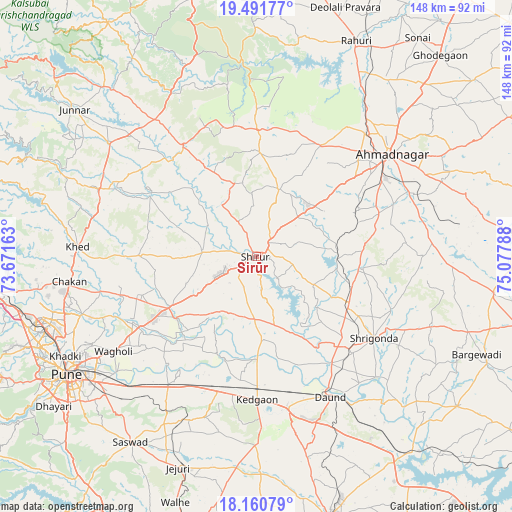
Sirūr GPS coordinates[2]
18° 49' 39.36" North, 74° 22' 29.1" East
| Map corner | latitude | longitude |
|---|---|---|
| Upper-left | 19.49177°, | 73.67163° |
| Center: | 18.8276°, | 74.37475° |
| Lower-right: | 18.16079°, | 75.07788° |
| Map W x H: | 148×148 km | = 92×92mi |
| max Lat: | 34.9274° ⇑69.1% North |
| Sirūr: | 18.8276° |
| min Lat: | ⇓30.9% South 8.09008° |
| min Long | Sirūr | max Long |
| 68.82655° | 74.37475° | 96.81° |
| W 12.4%⇐ | ⇒87.6% E |
Elevation
Elevation of Sirūr is 568 m = 1864 ft, and this is 272.4 m = 894 ft above average elevation for this country.
| Max E: |
3681 m = 12077 ft | 13.5% |
| Sirūr | 568 m 1864 ft | |
| Avg. | 295.6 m = 970 ft | |
Min E: |
1 m = 3 ft | 86.5% |
See also: India elevation on elevation.city.
Geographical zone
Sirūr is located in North Torrid zone (between Equator and Tropic of Cancer). Distance of this Northern Tropic circle is 512.5 km =318.5 mi to North.| Distance of | km | miles | from Sirūr |
|---|---|---|---|
| North Pole | 7913.6 | 4917.3 | to North |
| Arctic Circle | 5307.7 | 3298.1 | to North |
| Tropic Cancer | 512.5 | 318.5 | to North |
| Equator | 2093.4 | 1300.8 | to South |


Nearby cities:
15 places around Sirūr: (largest is in red/bold)
• Ahmadnagar
48.4 km =30.1 mi,  52°
52°
• Alandi
52.8 km =32.8 mi,  251°
251°
• Chākan
54.3 km =33.7 mi,  262°
262°
• Daund
45.9 km =28.5 mi,  151°
151°
• Kalamb
50.2 km =31.2 mi,  298°
298°
• Khadki
62.4 km =38.8 mi,  241°
241°
• Koregaon
38.9 km =24.2 mi, 238°
• Lohogaon
53.6 km =33.3 mi, 241°
• Manchar
49.4 km =30.7 mi,  293°
293°
• Pimpri
64 km =39.8 mi, 249°
• Pune
64.5 km =40.1 mi, 237°
• Rājgurunagar
50.1 km =31.1 mi,  274°
274°
• Shivaji Nagar
64.2 km =39.9 mi, 238°
• Shrīgonda
41.5 km =25.8 mi,  124°
124°
• Ārangaon
42.1 km =26.2 mi,  58°
58°
Sources, notices
• [Note1] Compared only with cities in India existing in our database
• [Src1] Map data: © OpenStreetMap contributors (CC-BY-SA)
• [Src2] Other city data from geonames.org with taken over terms of usage.
• [Src3] Geographical zone / Annual Mean Temperature by Robert A. Rohde @ Wikipedia
