Mundra geodata
Mundra (Gujarat) is a populated place; located in India in Asia/Kolkata (GMT+5.5) time zone. With population of 15,220 people, there are 2441 cities with bigger population in this country. Compared to other cities in India, 50.4% of cities are located further ↓South; 99.7% of cities are located further →East and 89.9% of cities have higher elevation than Mundra. Note1


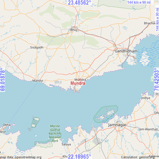
Mundra GPS coordinates[2]
22° 50' 21.048" North, 69° 43' 18.84" East
| Map corner | latitude | longitude |
|---|---|---|
| Upper-left | 23.48562°, | 69.01878° |
| Center: | 22.83918°, | 69.7219° |
| Lower-right: | 22.18965°, | 70.42503° |
| Map W x H: | 144.1×144.1 km | = 89.5×89.5mi |
| max Lat: | 34.9274° ⇑49.6% North |
| Mundra: | 22.83918° |
| min Lat: | ⇓50.4% South 8.09008° |
| min Long | Mundra | max Long |
| 68.82655° | 69.7219° | 96.81° |
| W 0.3%⇐ | ⇒99.7% E |
Elevation
Elevation of Mundra is 18 m = 59 ft, and this is 277.6 m = 911 ft below average elevation for this country.
| Max E: |
3681 m = 12077 ft | 89.9% |
| Avg. | 295.6 m = 970 ft | |
| Mundra | 18 m = 59 ft | |
Min E: |
1 m = 3 ft | 10.1% |
See also: India elevation on elevation.city.
Geographical zone
Mundra is located in North Torrid zone (between Equator and Tropic of Cancer). Distance of this Northern Tropic circle is 66.4 km =41.3 mi to North.| Distance of | km | miles | from Mundra |
|---|---|---|---|
| North Pole | 7467.6 | 4640.2 | to North |
| Arctic Circle | 4861.7 | 3020.9 | to North |
| Tropic Cancer | 66.4 | 41.3 | to North |
| Equator | 2539.5 | 1578 | to South |


Nearby cities:
15 places around Mundra: (largest is in red/bold)
• Anjār
43.6 km =27.1 mi,  45°
45°
• Bedi
50 km =31.1 mi,  138°
138°
• Bhuj
46.4 km =28.8 mi,  353°
353°
• Dhrol
77.5 km =48.2 mi,  112°
112°
• Gāndhīdhām
50.1 km =31.1 mi,  57°
57°
• Jamnagar
53.9 km =33.5 mi, 139°
• Jodiya Bandar
59.1 km =36.7 mi,  103°
103°
• Khambhāliya
70.7 km =43.9 mi,  185°
185°
• Kāndla
55.1 km =34.2 mi,  66°
66°
• Lālpur
76.3 km =47.4 mi,  161°
161°
• Māndvi
37.9 km =23.5 mi,  268°
268°
• Okha
78.6 km =48.8 mi,  238°
238°
• Roha
60.9 km =37.8 mi,  310°
310°
• Salāya
60 km =37.3 mi, 191°
• Sikka
46.9 km =29.1 mi, 164°
Sources, notices
• [Note1] Compared only with cities in India existing in our database
• [Src1] Map data: © OpenStreetMap contributors (CC-BY-SA)
• [Src2] Other city data from geonames.org with taken over terms of usage.
• [Src3] Geographical zone / Annual Mean Temperature by Robert A. Rohde @ Wikipedia
