Bedi geodata
Bedi (Gujarat) is a populated place; located in India in Asia/Kolkata (GMT+5.5) time zone. With population of 21,327 people, there are 1948 cities with bigger population in this country. Compared to other cities in India, 53.2% of cities are located further ↑North; 99.5% of cities are located further →East and 97.4% of cities have higher elevation than Bedi. Note1


Bedi GPS coordinates[2]
22° 30' 5.148" North, 70° 2' 37.068" East
| Map corner | latitude | longitude |
|---|---|---|
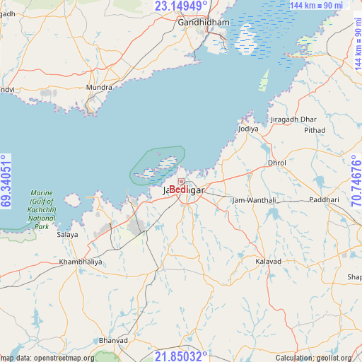
| Upper-left | 23.14949°, | 69.34051° |
| Center: | 22.50143°, | 70.04363° |
| Lower-right: | 21.85032°, | 70.74676° |
| Map W x H: | 144.5×144.5 km | = 89.8×89.8mi |
| max Lat: | 34.9274° ⇑53.2% North |
| Bedi: | 22.50143° |
| min Lat: | ⇓46.8% South 8.09008° |
| min Long | Bedi | max Long |
| 68.82655° | 70.04363° | 96.81° |
| W 0.5%⇐ | ⇒99.5% E |
Elevation
Elevation of Bedi is 9 m = 30 ft, and this is 286.6 m = 940 ft below average elevation for this country.
| Max E: |
3681 m = 12077 ft | 97.4% |
| Avg. | 295.6 m = 970 ft | |
| Bedi | 9 m = 30 ft | |
Min E: |
1 m = 3 ft | 2.6% |
See also: India elevation on elevation.city.
Geographical zone
Bedi is located in North Torrid zone (between Equator and Tropic of Cancer). Distance of this Northern Tropic circle is 104 km =64.6 mi to North.| Distance of | km | miles | from Bedi |
|---|---|---|---|
| North Pole | 7505.1 | 4663.5 | to North |
| Arctic Circle | 4899.2 | 3044.2 | to North |
| Tropic Cancer | 104 | 64.6 | to North |
| Equator | 2501.9 | 1554.6 | to South |


Nearby cities:
15 places around Bedi: (largest is in red/bold)
• Anjār
68 km =42.3 mi,  358°
358°
• Bhānvad
69 km =42.9 mi,  203°
203°
• Dhrol
39.1 km =24.3 mi,  79°
79°
• Gāndhīdhām
65.4 km =40.6 mi,  8°
8°
• Jamnagar
4 km =2.5 mi,  143°
143°
• Jodhpur
66.7 km =41.4 mi,  180°
180°
• Jodiya Bandar
34.3 km =21.3 mi,  45°
45°
• Khambhāliya
52 km =32.3 mi,  230°
230°
• Kālāvad
47.8 km =29.7 mi,  133°
133°
• Kāndla
61.7 km =38.3 mi,  16°
16°
• Lālpur
35.5 km =22.1 mi,  193°
193°
• Mundra
50 km =31.1 mi,  318°
318°
• Paddhari
57.8 km =35.9 mi,  97°
97°
• Salāya
50 km =31.1 mi,  244°
244°
• Sikka
22.1 km =13.7 mi,  249°
249°
Sources, notices
• [Note1] Compared only with cities in India existing in our database
• [Src1] Map data: © OpenStreetMap contributors (CC-BY-SA)
• [Src2] Other city data from geonames.org with taken over terms of usage.
• [Src3] Geographical zone / Annual Mean Temperature by Robert A. Rohde @ Wikipedia
