Salāya geodata
Salāya (Gujarat) is a populated place; located in India in Asia/Kolkata (GMT+5.5) time zone. With population of 30,228 people, there are 1435 cities with bigger population in this country. Compared to other cities in India, 54.4% of cities are located further ↑North; 99.8% of cities are located further →East and 98.3% of cities have higher elevation than Salāya. Note1


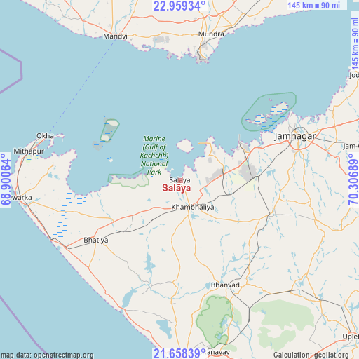
Salāya GPS coordinates[2]
22° 18' 37.368" North, 69° 36' 13.536" East
| Map corner | latitude | longitude |
|---|---|---|
| Upper-left | 22.95934°, | 68.90064° |
| Center: | 22.31038°, | 69.60376° |
| Lower-right: | 21.65839°, | 70.30689° |
| Map W x H: | 144.7×144.7 km | = 89.9×89.9mi |
| max Lat: | 34.9274° ⇑54.4% North |
| Salāya: | 22.31038° |
| min Lat: | ⇓45.6% South 8.09008° |
| min Long | Salāya | max Long |
| 68.82655° | 69.60376° | 96.81° |
| W 0.2%⇐ | ⇒99.8% E |
Elevation
Elevation of Salāya is 8 m = 26 ft, and this is 287.6 m = 944 ft below average elevation for this country.
| Max E: |
3681 m = 12077 ft | 98.3% |
| Avg. | 295.6 m = 970 ft | |
| Salāya | 8 m = 26 ft | |
Min E: |
1 m = 3 ft | 1.7% |
See also: India elevation on elevation.city.
Geographical zone
Salāya is located in North Torrid zone (between Equator and Tropic of Cancer). Distance of this Northern Tropic circle is 125.2 km =77.8 mi to North.| Distance of | km | miles | from Salāya |
|---|---|---|---|
| North Pole | 7526.4 | 4676.7 | to North |
| Arctic Circle | 4920.5 | 3057.5 | to North |
| Tropic Cancer | 125.2 | 77.8 | to North |
| Equator | 2480.7 | 1541.4 | to South |


Nearby cities:
15 places around Salāya: (largest is in red/bold)
• Bedi
50 km =31.1 mi,  64°
64°
• Bhānvad
46 km =28.6 mi,  156°
156°
• Dwārka
65.9 km =40.9 mi,  263°
263°
• Jamnagar
50.9 km =31.6 mi,  69°
69°
• Jodhpur
63.4 km =39.4 mi,  135°
135°
• Jodiya Bandar
83.1 km =51.6 mi, 57°
• Khambhāliya
12.5 km =7.8 mi, 157°
• Kālāvad
81 km =50.3 mi,  98°
98°
• Lālpur
39.3 km =24.4 mi,  109°
109°
• Mundra
60 km =37.3 mi,  11°
11°
• Māndvi
63.6 km =39.5 mi,  336°
336°
• Okha
57.6 km =35.8 mi,  287°
287°
• Porbandar
74.3 km =46.2 mi,  179°
179°
• Rānāvāv
70.8 km =44 mi,  168°
168°
• Sikka
28 km =17.4 mi, 61°
Sources, notices
• [Note1] Compared only with cities in India existing in our database
• [Src1] Map data: © OpenStreetMap contributors (CC-BY-SA)
• [Src2] Other city data from geonames.org with taken over terms of usage.
• [Src3] Geographical zone / Annual Mean Temperature by Robert A. Rohde @ Wikipedia
