Okha geodata
Okha (Gujarat) is a populated place; located in India in Asia/Kolkata (GMT+5.5) time zone. With population of 21,048 people, there are 1963 cities with bigger population in this country. Compared to other cities in India, 53.4% of cities are located further ↑North; 99.9% of cities are located further →East and 99% of cities have higher elevation than Okha. Note1


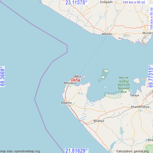
Okha GPS coordinates[2]
22° 28' 3.216" North, 69° 4' 12.072" East
| Map corner | latitude | longitude |
|---|---|---|
| Upper-left | 23.11578°, | 68.3669° |
| Center: | 22.46756°, | 69.07002° |
| Lower-right: | 21.81629°, | 69.77315° |
| Map W x H: | 144.5×144.5 km | = 89.8×89.8mi |
| max Lat: | 34.9274° ⇑53.4% North |
| Okha: | 22.46756° |
| min Lat: | ⇓46.6% South 8.09008° |
| min Long | Okha | max Long |
| 68.82655° | 69.07002° | 96.81° |
| W 0.1%⇐ | ⇒99.9% E |
Elevation
Elevation of Okha is 7 m = 23 ft, and this is 288.6 m = 947 ft below average elevation for this country.
| Max E: |
3681 m = 12077 ft | 99% |
| Avg. | 295.6 m = 970 ft | |
| Okha | 7 m = 23 ft | |
Min E: |
1 m = 3 ft | 1% |
See also: India elevation on elevation.city.
Geographical zone
Okha is located in North Torrid zone (between Equator and Tropic of Cancer). Distance of this Northern Tropic circle is 107.8 km =67 mi to North.| Distance of | km | miles | from Okha |
|---|---|---|---|
| North Pole | 7508.9 | 4665.8 | to North |
| Arctic Circle | 4903 | 3046.6 | to North |
| Tropic Cancer | 107.8 | 67 | to North |
| Equator | 2498.2 | 1552.3 | to South |


Nearby cities:
15 places around Okha: (largest is in red/bold)
• Bedi
100.1 km =62.2 mi,  87°
87°
• Bhuj
106.8 km =66.4 mi,  35°
35°
• Bhānvad
94.4 km =58.7 mi,  129°
129°
• Dwārka
27.5 km =17.1 mi,  202°
202°
• Jamnagar
102.4 km =63.6 mi, 89°
• Khambhāliya
66.3 km =41.2 mi,  115°
115°
• Lālpur
96.9 km =60.2 mi,  108°
108°
• Mundra
78.6 km =48.8 mi,  58°
58°
• Māndvi
49.9 km =31 mi, 35°
• Naliya
91.6 km =56.9 mi,  344°
344°
• Porbandar
107.3 km =66.7 mi,  148°
148°
• Roha
83.6 km =51.9 mi,  14°
14°
• Rānāvāv
111.2 km =69.1 mi,  141°
141°
• Salāya
57.6 km =35.8 mi, 107°
• Sikka
79.4 km =49.3 mi, 92°
Sources, notices
• [Note1] Compared only with cities in India existing in our database
• [Src1] Map data: © OpenStreetMap contributors (CC-BY-SA)
• [Src2] Other city data from geonames.org with taken over terms of usage.
• [Src3] Geographical zone / Annual Mean Temperature by Robert A. Rohde @ Wikipedia
