Karwar geodata
Karwar (Karnataka) is a populated place; located in India in Asia/Kolkata (GMT+5.5) time zone. With population of 64,457 people, there are 684 cities with bigger population in this country. Compared to other cities in India, 81.9% of cities are located further ↑North; 88.7% of cities are located further →East and 97.4% of cities have higher elevation than Karwar. Note1


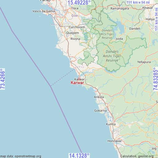
Karwar GPS coordinates[2]
14° 48' 48.996" North, 74° 7' 46.992" East
| Map corner | latitude | longitude |
|---|---|---|
| Upper-left | 15.49228°, | 73.4266° |
| Center: | 14.81361°, | 74.12972° |
| Lower-right: | 14.1328°, | 74.83285° |
| Map W x H: | 151.2×151.2 km | = 94×94mi |
| max Lat: | 34.9274° ⇑81.9% North |
| Karwar: | 14.81361° |
| min Lat: | ⇓18.1% South 8.09008° |
| min Long | Karwar | max Long |
| 68.82655° | 74.12972° | 96.81° |
| W 11.3%⇐ | ⇒88.7% E |
Elevation
Elevation of Karwar is 9 m = 30 ft, and this is 286.6 m = 940 ft below average elevation for this country.
| Max E: |
3681 m = 12077 ft | 97.4% |
| Avg. | 295.6 m = 970 ft | |
| Karwar | 9 m = 30 ft | |
Min E: |
1 m = 3 ft | 2.6% |
See also: Karwar elevation on elevation.city.
Geographical zone
Karwar is located in North Torrid zone (between Equator and Tropic of Cancer). Distance of this Northern Tropic circle is 958.8 km =595.8 mi to North.| Distance of | km | miles | from Karwar |
|---|---|---|---|
| North Pole | 8359.9 | 5194.6 | to North |
| Arctic Circle | 5754.1 | 3575.4 | to North |
| Tropic Cancer | 958.8 | 595.8 | to North |
| Equator | 1647.1 | 1023.5 | to South |


Nearby cities:
15 places around Karwar: (largest is in red/bold)
• Ankola
25.4 km =15.8 mi,  132°
132°
• Canacona
22 km =13.7 mi,  337°
337°
• Cavelossim
44.7 km =27.8 mi,  333°
333°
• Chinchinim
47.5 km =29.5 mi, 339°
• Cuncolim
43 km =26.7 mi, 340°
• Curchorem
50.1 km =31.1 mi,  357°
357°
• Davorlim
53.1 km =33 mi, 343°
• Gokarna
35.5 km =22.1 mi,  145°
145°
• Kumta
52.9 km =32.9 mi,  143°
143°
• Kānkon
25.4 km =15.8 mi, 339°
• Madgaon
54.5 km =33.9 mi, 340°
• Quepem
44.7 km =27.8 mi,  352°
352°
• Sanguem
46.2 km =28.7 mi,  2°
2°
• Sanvordem
49.9 km =31 mi, 358°
• Varca
50.7 km =31.5 mi, 336°
Sources, notices
• [Note1] Compared only with cities in India existing in our database
• [Src1] Map data: © OpenStreetMap contributors (CC-BY-SA)
• [Src2] Other city data from geonames.org with taken over terms of usage.
• [Src3] Geographical zone / Annual Mean Temperature by Robert A. Rohde @ Wikipedia
