Ankola geodata
Ankola (Karnataka) is a populated place; located in India in Asia/Kolkata (GMT+5.5) time zone. With population of 14,540 people, there are 2506 cities with bigger population in this country. Compared to other cities in India, 82.1% of cities are located further ↑North; 87.9% of cities are located further →East and 90.4% of cities have higher elevation than Ankola. Note1


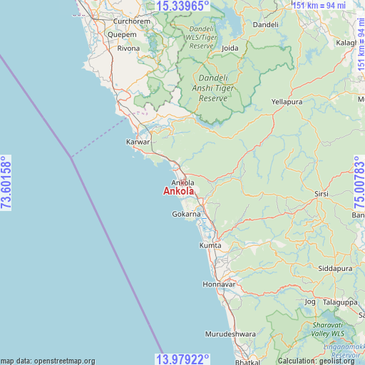
Ankola GPS coordinates[2]
14° 39' 37.764" North, 74° 18' 16.92" East
| Map corner | latitude | longitude |
|---|---|---|
| Upper-left | 15.33965°, | 73.60158° |
| Center: | 14.66049°, | 74.3047° |
| Lower-right: | 13.97922°, | 75.00783° |
| Map W x H: | 151.3×151.3 km | = 94×94mi |
| max Lat: | 34.9274° ⇑82.1% North |
| Ankola: | 14.66049° |
| min Lat: | ⇓17.9% South 8.09008° |
| min Long | Ankola | max Long |
| 68.82655° | 74.3047° | 96.81° |
| W 12.1%⇐ | ⇒87.9% E |
Elevation
Elevation of Ankola is 17 m = 56 ft, and this is 278.6 m = 914 ft below average elevation for this country.
| Max E: |
3681 m = 12077 ft | 90.4% |
| Avg. | 295.6 m = 970 ft | |
| Ankola | 17 m = 56 ft | |
Min E: |
1 m = 3 ft | 9.6% |
See also: India elevation on elevation.city.
Geographical zone
Ankola is located in North Torrid zone (between Equator and Tropic of Cancer). Distance of this Northern Tropic circle is 975.8 km =606.3 mi to North.| Distance of | km | miles | from Ankola |
|---|---|---|---|
| North Pole | 8377 | 5205.2 | to North |
| Arctic Circle | 5771.1 | 3586 | to North |
| Tropic Cancer | 975.8 | 606.3 | to North |
| Equator | 1630.1 | 1012.9 | to South |


Nearby cities:
15 places around Ankola: (largest is in red/bold)
• Canacona
46.2 km =28.7 mi,  323°
323°
• Cavelossim
69 km =42.9 mi,  325°
325°
• Cuncolim
66.5 km =41.3 mi, 329°
• Curchorem
70.3 km =43.7 mi,  342°
342°
• Gokarna
12.4 km =7.7 mi,  174°
174°
• Honāvar
44.8 km =27.8 mi,  160°
160°
• Karwar
25.4 km =15.8 mi,  312°
312°
• Kumta
28.6 km =17.8 mi,  154°
154°
• Kānkon
49.3 km =30.6 mi, 325°
• Murudeshwara
65.9 km =40.9 mi, 162°
• Quepem
66.1 km =41.1 mi, 338°
• Sanguem
65.3 km =40.6 mi,  345°
345°
• Sanvordem
69.8 km =43.4 mi, 343°
• Sirsi
57.3 km =35.6 mi,  94°
94°
• Yellāpur
55 km =34.2 mi,  52°
52°
Sources, notices
• [Note1] Compared only with cities in India existing in our database
• [Src1] Map data: © OpenStreetMap contributors (CC-BY-SA)
• [Src2] Other city data from geonames.org with taken over terms of usage.
• [Src3] Geographical zone / Annual Mean Temperature by Robert A. Rohde @ Wikipedia
