Kumta geodata
Kumta (Karnataka) is a populated place; located in India in Asia/Kolkata (GMT+5.5) time zone. With population of 27,999 people, there are 1538 cities with bigger population in this country. Compared to other cities in India, 82.6% of cities are located further ↑North; 87.4% of cities are located further →East and 83% of cities have higher elevation than Kumta. Note1


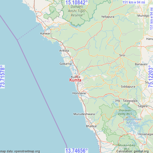
Kumta GPS coordinates[2]
14° 25' 42.708" North, 74° 25' 8.04" East
| Map corner | latitude | longitude |
|---|---|---|
| Upper-left | 15.10842°, | 73.71578° |
| Center: | 14.42853°, | 74.4189° |
| Lower-right: | 13.74656°, | 75.12203° |
| Map W x H: | 151.4×151.4 km | = 94.1×94.1mi |
| max Lat: | 34.9274° ⇑82.6% North |
| Kumta: | 14.42853° |
| min Lat: | ⇓17.4% South 8.09008° |
| min Long | Kumta | max Long |
| 68.82655° | 74.4189° | 96.81° |
| W 12.6%⇐ | ⇒87.4% E |
Elevation
Elevation of Kumta is 37 m = 121 ft, and this is 258.6 m = 848 ft below average elevation for this country.
| Max E: |
3681 m = 12077 ft | 83% |
| Avg. | 295.6 m = 970 ft | |
| Kumta | 37 m = 121 ft | |
Min E: |
1 m = 3 ft | 17% |
See also: India elevation on elevation.city.
Geographical zone
Kumta is located in North Torrid zone (between Equator and Tropic of Cancer). Distance of this Northern Tropic circle is 1001.6 km =622.4 mi to North.| Distance of | km | miles | from Kumta |
|---|---|---|---|
| North Pole | 8402.8 | 5221.3 | to North |
| Arctic Circle | 5796.9 | 3602 | to North |
| Tropic Cancer | 1001.6 | 622.4 | to North |
| Equator | 1604.3 | 996.9 | to South |


Nearby cities:
15 places around Kumta: (largest is in red/bold)
• Ankola
28.6 km =17.8 mi,  334°
334°
• Bhatkal
51.4 km =31.9 mi,  163°
163°
• Byndoor
66.6 km =41.4 mi, 159°
• Canacona
74.5 km =46.3 mi, 327°
• Gokarna
17.4 km =10.8 mi,  320°
320°
• Honāvar
16.7 km =10.4 mi,  170°
170°
• Hāngal
84.6 km =52.6 mi,  63°
63°
• Karwar
52.9 km =32.9 mi, 323°
• Kānkon
77.7 km =48.3 mi, 328°
• Murudeshwara
37.8 km =23.5 mi, 169°
• Siddāpur
52 km =32.3 mi,  100°
100°
• Sirsi
49.7 km =30.9 mi, 64°
• Sorab
72.7 km =45.2 mi,  94°
94°
• Sāgar
72 km =44.7 mi,  114°
114°
• Yellāpur
67.2 km =41.8 mi,  27°
27°
Sources, notices
• [Note1] Compared only with cities in India existing in our database
• [Src1] Map data: © OpenStreetMap contributors (CC-BY-SA)
• [Src2] Other city data from geonames.org with taken over terms of usage.
• [Src3] Geographical zone / Annual Mean Temperature by Robert A. Rohde @ Wikipedia
