Karur geodata
Karur (Tamil Nadu) is a populated place; located in India in Asia/Kolkata (GMT+5.5) time zone. With population of 76,915 people, there are 568 cities with bigger population in this country. Compared to other cities in India, 93.4% of cities are located further ↑North; 50.5% of cities are located further →East and 64.2% of cities have higher elevation than Karur. Note1


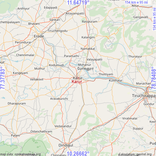
Karur GPS coordinates[2]
10° 57' 27.756" North, 78° 4' 51.42" East
| Map corner | latitude | longitude |
|---|---|---|
| Upper-left | 11.64719°, | 77.37783° |
| Center: | 10.95771°, | 78.08095° |
| Lower-right: | 10.26662°, | 78.78408° |
| Map W x H: | 153.5×153.5 km | = 95.4×95.4mi |
| max Lat: | 34.9274° ⇑93.4% North |
| Karur: | 10.95771° |
| min Lat: | ⇓6.6% South 8.09008° |
| min Long | Karur | max Long |
| 68.82655° | 78.08095° | 96.81° |
| W 49.5%⇐ | ⇒50.5% E |
Elevation
Elevation of Karur is 126 m = 413 ft, and this is 169.6 m = 556 ft below average elevation for this country.
| Max E: |
3681 m = 12077 ft | 64.2% |
| Avg. | 295.6 m = 970 ft | |
| Karur | 126 m = 413 ft | |
Min E: |
1 m = 3 ft | 35.8% |
See also: Karur elevation on elevation.city.
Geographical zone
Karur is located in North Torrid zone (between Equator and Tropic of Cancer). Distance of Equator is 1218.4 km =757.1 mi to South.| Distance of | km | miles | from Karur |
|---|---|---|---|
| North Pole | 8788.7 | 5461 | to North |
| Arctic Circle | 6182.8 | 3841.8 | to North |
| Tropic Cancer | 1387.5 | 862.2 | to North |
| Equator | 1218.4 | 757.1 | to South |


Nearby cities:
15 places around Karur: (largest is in red/bold)
• Erumaippatti
31 km =19.3 mi,  47°
47°
• Kodumudi
25.3 km =15.7 mi,  301°
301°
• Kulittalai
36.3 km =22.6 mi,  94°
94°
• Kāttupputtūr
15.6 km =9.7 mi,  75°
75°
• Mettuppālaiyam
46.5 km =28.9 mi,  59°
59°
• Mohanūr
13 km =8.1 mi,  29°
29°
• Musiri
39.7 km =24.7 mi, 90°
• Mūlanūr
44.2 km =27.5 mi,  245°
245°
• Nāmakkal
30.7 km =19.1 mi,  17°
17°
• Pallappatti
34.3 km =21.3 mi,  219°
219°
• Puduppatti
25.9 km =16.1 mi, 33°
• Sivagiri
36.7 km =22.8 mi, 299°
• Tāttayyangārpettai
44.2 km =27.5 mi,  65°
65°
• Vedasandūr
49.5 km =30.8 mi,  196°
196°
• Velur
18.9 km =11.7 mi,  332°
332°
Sources, notices
• [Note1] Compared only with cities in India existing in our database
• [Src1] Map data: © OpenStreetMap contributors (CC-BY-SA)
• [Src2] Other city data from geonames.org with taken over terms of usage.
• [Src3] Geographical zone / Annual Mean Temperature by Robert A. Rohde @ Wikipedia
