Vedasandūr geodata
Vedasandūr (Tamil Nadu) is a populated place; located in India in Asia/Kolkata (GMT+5.5) time zone. With population of 12,493 people, there are 2701 cities with bigger population in this country. Compared to other cities in India, 94.9% of cities are located further ↑North; 51.7% of cities are located further →East and 53% of cities have lower elevation than Vedasandūr. Note1


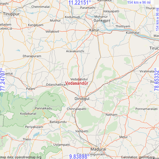
Vedasandūr GPS coordinates[2]
10° 31' 51.672" North, 77° 57' 0.684" East
| Map corner | latitude | longitude |
|---|---|---|
| Upper-left | 11.22151°, | 77.24707° |
| Center: | 10.53102°, | 77.95019° |
| Lower-right: | 9.83898°, | 78.65332° |
| Map W x H: | 153.7×153.7 km | = 95.5×95.5mi |
| max Lat: | 34.9274° ⇑94.9% North |
| Vedasandūr: | 10.53102° |
| min Lat: | ⇓5.1% South 8.09008° |
| min Long | Vedasandūr | max Long |
| 68.82655° | 77.95019° | 96.81° |
| W 48.3%⇐ | ⇒51.7% E |
Elevation
Elevation of Vedasandūr is 218 m = 715 ft, and this is 77.6 m = 255 ft below average elevation for this country.
| Max E: |
3681 m = 12077 ft | 47% |
| Avg. | 295.6 m = 970 ft | |
| Vedasandūr | 218 m = 715 ft | |
Min E: |
1 m = 3 ft | 53% |
See also: India elevation on elevation.city.
Geographical zone
Vedasandūr is located in North Torrid zone (between Equator and Tropic of Cancer). Distance of Equator is 1170.9 km =727.6 mi to South.| Distance of | km | miles | from Vedasandūr |
|---|---|---|---|
| North Pole | 8836.1 | 5490.5 | to North |
| Arctic Circle | 6230.2 | 3871.3 | to North |
| Tropic Cancer | 1435 | 891.7 | to North |
| Equator | 1170.9 | 727.6 | to South |


Nearby cities:
15 places around Vedasandūr: (largest is in red/bold)
• Ayakudi
44.5 km =27.7 mi,  258°
258°
• Dharapuram
51.2 km =31.8 mi,  296°
296°
• Dindigul
18.3 km =11.4 mi,  169°
169°
• Karur
49.5 km =30.8 mi,  16°
16°
• Kīranūr
49.4 km =30.7 mi,  278°
278°
• Mūlanūr
39.2 km =24.4 mi,  318°
318°
• Nattam
45.5 km =28.3 mi,  137°
137°
• Nilakottai
42.1 km =26.2 mi,  195°
195°
• Palani
47.8 km =29.7 mi, 259°
• Pallappatti
22.4 km =13.9 mi,  339°
339°
• Pālamedu
50.6 km =31.4 mi,  159°
159°
• V.S.K.Valasai (Dindigul-Dist.)
32.5 km =20.2 mi, 137°
• Vadamadurai
19 km =11.8 mi,  121°
121°
• Vattalkundu
46.2 km =28.7 mi,  206°
206°
• Vādippatti
49.6 km =30.8 mi,  178°
178°
Sources, notices
• [Note1] Compared only with cities in India existing in our database
• [Src1] Map data: © OpenStreetMap contributors (CC-BY-SA)
• [Src2] Other city data from geonames.org with taken over terms of usage.
• [Src3] Geographical zone / Annual Mean Temperature by Robert A. Rohde @ Wikipedia
