Kodumudi geodata
Kodumudi (Tamil Nadu) is a populated place; located in India in Asia/Kolkata (GMT+5.5) time zone. With population of 13,053 people, there are 2653 cities with bigger population in this country. Compared to other cities in India, 92.9% of cities are located further ↑North; 52.5% of cities are located further →East and 62.5% of cities have higher elevation than Kodumudi. Note1


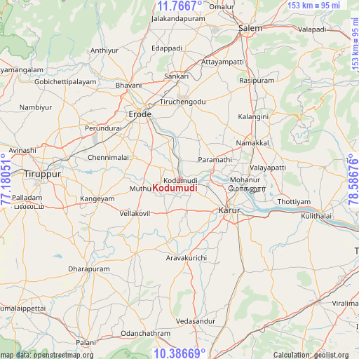
Kodumudi GPS coordinates[2]
11° 4' 39.036" North, 77° 53' 1.068" East
| Map corner | latitude | longitude |
|---|---|---|
| Upper-left | 11.7667°, | 77.18051° |
| Center: | 11.07751°, | 77.88363° |
| Lower-right: | 10.38669°, | 78.58676° |
| Map W x H: | 153.4×153.4 km | = 95.3×95.3mi |
| max Lat: | 34.9274° ⇑92.9% North |
| Kodumudi: | 11.07751° |
| min Lat: | ⇓7.1% South 8.09008° |
| min Long | Kodumudi | max Long |
| 68.82655° | 77.88363° | 96.81° |
| W 47.5%⇐ | ⇒52.5% E |
Elevation
Elevation of Kodumudi is 135 m = 443 ft, and this is 160.6 m = 527 ft below average elevation for this country.
| Max E: |
3681 m = 12077 ft | 62.5% |
| Avg. | 295.6 m = 970 ft | |
| Kodumudi | 135 m = 443 ft | |
Min E: |
1 m = 3 ft | 37.5% |
See also: India elevation on elevation.city.
Geographical zone
Kodumudi is located in North Torrid zone (between Equator and Tropic of Cancer). Distance of Equator is 1231.7 km =765.3 mi to South.| Distance of | km | miles | from Kodumudi |
|---|---|---|---|
| North Pole | 8775.4 | 5452.8 | to North |
| Arctic Circle | 6169.5 | 3833.5 | to North |
| Tropic Cancer | 1374.2 | 853.9 | to North |
| Equator | 1231.7 | 765.3 | to South |


Nearby cities:
15 places around Kodumudi: (largest is in red/bold)
• Chennimalai
32 km =19.9 mi,  287°
287°
• Erode
34.1 km =21.2 mi,  329°
329°
• Erumaippatti
45 km =28 mi,  80°
80°
• Kangayam
36.1 km =22.4 mi,  257°
257°
• Karur
25.3 km =15.7 mi,  121°
121°
• Kāttupputtūr
37.8 km =23.5 mi,  104°
104°
• Mohanūr
28 km =17.4 mi,  94°
94°
• Mūlanūr
36.7 km =22.8 mi,  210°
210°
• Nāmakkal
34.6 km =21.5 mi,  62°
62°
• Pallappatti
39.7 km =24.7 mi,  180°
180°
• Perundurai
39.1 km =24.3 mi,  304°
304°
• Puduppatti
36.8 km =22.9 mi, 76°
• Sivagiri
11.5 km =7.1 mi, 294°
• Tiruchengode
33.7 km =20.9 mi,  2°
2°
• Velur
13.3 km =8.3 mi, 75°
Sources, notices
• [Note1] Compared only with cities in India existing in our database
• [Src1] Map data: © OpenStreetMap contributors (CC-BY-SA)
• [Src2] Other city data from geonames.org with taken over terms of usage.
• [Src3] Geographical zone / Annual Mean Temperature by Robert A. Rohde @ Wikipedia
