Nāmakkal geodata
Nāmakkal (Tamil Nadu) is a populated place; located in India in Asia/Kolkata (GMT+5.5) time zone. With population of 55,997 people, there are 795 cities with bigger population in this country. Compared to other cities in India, 92.3% of cities are located further ↑North; 50.8% of cities are located further ←West and 54.2% of cities have lower elevation than Nāmakkal. Note1


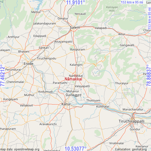
Nāmakkal GPS coordinates[2]
11° 13' 16.536" North, 78° 9' 54.864" East
| Map corner | latitude | longitude |
|---|---|---|
| Upper-left | 11.9101°, | 77.46212° |
| Center: | 11.22126°, | 78.16524° |
| Lower-right: | 10.53077°, | 78.86837° |
| Map W x H: | 153.4×153.4 km | = 95.3×95.3mi |
| max Lat: | 34.9274° ⇑92.3% North |
| Nāmakkal: | 11.22126° |
| min Lat: | ⇓7.7% South 8.09008° |
| min Long | Nāmakkal | max Long |
| 68.82655° | 78.16524° | 96.81° |
| W 50.8%⇐ | ⇒49.2% E |
Elevation
Elevation of Nāmakkal is 223 m = 732 ft, and this is 72.6 m = 238 ft below average elevation for this country.
| Max E: |
3681 m = 12077 ft | 45.8% |
| Avg. | 295.6 m = 970 ft | |
| Nāmakkal | 223 m = 732 ft | |
Min E: |
1 m = 3 ft | 54.2% |
See also: Nāmakkal elevation on elevation.city.
Geographical zone
Nāmakkal is located in North Torrid zone (between Equator and Tropic of Cancer). Distance of Equator is 1247.7 km =775.3 mi to South.| Distance of | km | miles | from Nāmakkal |
|---|---|---|---|
| North Pole | 8759.4 | 5442.8 | to North |
| Arctic Circle | 6153.5 | 3823.6 | to North |
| Tropic Cancer | 1358.2 | 843.9 | to North |
| Equator | 1247.7 | 775.3 | to South |


Nearby cities:
15 places around Nāmakkal: (largest is in red/bold)
• Erumaippatti
15.9 km =9.9 mi,  121°
121°
• Karur
30.7 km =19.1 mi,  197°
197°
• Kodumudi
34.6 km =21.5 mi,  242°
242°
• Kāttupputtūr
26 km =16.2 mi,  166°
166°
• Mallasamudram
33.6 km =20.9 mi,  334°
334°
• Mettuppālaiyam
31.6 km =19.6 mi,  100°
100°
• Mohanūr
18.2 km =11.3 mi,  188°
188°
• Māllūr
36 km =22.4 mi,  355°
355°
• Nāmagiripettai
28.3 km =17.6 mi,  23°
23°
• Puduppatti
9.2 km =5.7 mi,  146°
146°
• Rasipuram
26.7 km =16.6 mi,  4°
4°
• Tiruchengode
34.4 km =21.4 mi,  300°
300°
• Tāttayyangārpettai
32.8 km =20.4 mi,  109°
109°
• Velur
21.9 km =13.6 mi,  234°
234°
• Āttayyāmpatti
36.7 km =22.8 mi,  340°
340°
Sources, notices
• [Note1] Compared only with cities in India existing in our database
• [Src1] Map data: © OpenStreetMap contributors (CC-BY-SA)
• [Src2] Other city data from geonames.org with taken over terms of usage.
• [Src3] Geographical zone / Annual Mean Temperature by Robert A. Rohde @ Wikipedia
