Pallappatti geodata
Pallappatti (Tamil Nadu) is a populated place; located in India in Asia/Kolkata (GMT+5.5) time zone. With population of 20,281 people, there are 2017 cities with bigger population in this country. Compared to other cities in India, 94.3% of cities are located further ↑North; 52.6% of cities are located further →East and 52.4% of cities have higher elevation than Pallappatti. Note1


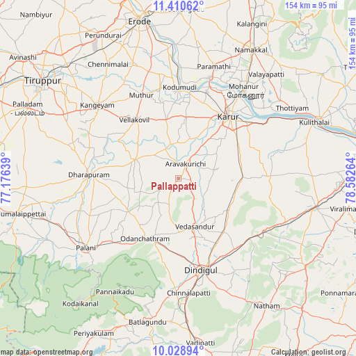
Pallappatti GPS coordinates[2]
10° 43' 14.052" North, 77° 52' 46.236" East
| Map corner | latitude | longitude |
|---|---|---|
| Upper-left | 11.41062°, | 77.17639° |
| Center: | 10.72057°, | 77.87951° |
| Lower-right: | 10.02894°, | 78.58264° |
| Map W x H: | 153.6×153.6 km | = 95.4×95.4mi |
| max Lat: | 34.9274° ⇑94.3% North |
| Pallappatti: | 10.72057° |
| min Lat: | ⇓5.7% South 8.09008° |
| min Long | Pallappatti | max Long |
| 68.82655° | 77.87951° | 96.81° |
| W 47.4%⇐ | ⇒52.6% E |
Elevation
Elevation of Pallappatti is 188 m = 617 ft, and this is 107.6 m = 353 ft below average elevation for this country.
| Max E: |
3681 m = 12077 ft | 52.4% |
| Avg. | 295.6 m = 970 ft | |
| Pallappatti | 188 m = 617 ft | |
Min E: |
1 m = 3 ft | 47.6% |
See also: India elevation on elevation.city.
Geographical zone
Pallappatti is located in North Torrid zone (between Equator and Tropic of Cancer). Distance of Equator is 1192 km =740.7 mi to South.| Distance of | km | miles | from Pallappatti |
|---|---|---|---|
| North Pole | 8815 | 5477.4 | to North |
| Arctic Circle | 6209.2 | 3858.2 | to North |
| Tropic Cancer | 1413.9 | 878.6 | to North |
| Equator | 1192 | 740.7 | to South |


Nearby cities:
15 places around Pallappatti: (largest is in red/bold)
• Ayakudi
46.8 km =29.1 mi,  229°
229°
• Dharapuram
38 km =23.6 mi,  272°
272°
• Dindigul
40.6 km =25.2 mi,  164°
164°
• Kangayam
47.1 km =29.3 mi,  312°
312°
• Karur
34.3 km =21.3 mi,  39°
39°
• Kodumudi
39.7 km =24.7 mi,  0°
0°
• Kāttupputtūr
48 km =29.8 mi,  50°
50°
• Kīranūr
43.5 km =27 mi,  251°
251°
• Mohanūr
47.2 km =29.3 mi, 37°
• Mūlanūr
20.1 km =12.5 mi,  294°
294°
• Palani
49.4 km =30.7 mi, 232°
• Sivagiri
45.5 km =28.3 mi,  347°
347°
• Vadamadurai
39.2 km =24.4 mi,  142°
142°
• Vedasandūr
22.4 km =13.9 mi, 159°
• Velur
45.1 km =28 mi,  17°
17°
Sources, notices
• [Note1] Compared only with cities in India existing in our database
• [Src1] Map data: © OpenStreetMap contributors (CC-BY-SA)
• [Src2] Other city data from geonames.org with taken over terms of usage.
• [Src3] Geographical zone / Annual Mean Temperature by Robert A. Rohde @ Wikipedia
