Kāndhla geodata
Kāndhla (Uttar Pradesh) is a populated place; located in India in Asia/Kolkata (GMT+5.5) time zone. With population of 43,387 people, there are 1018 cities with bigger population in this country. Compared to other cities in India, 90.3% of cities are located further ↓South; 60.3% of cities are located further →East and 59.9% of cities have lower elevation than Kāndhla. Note1


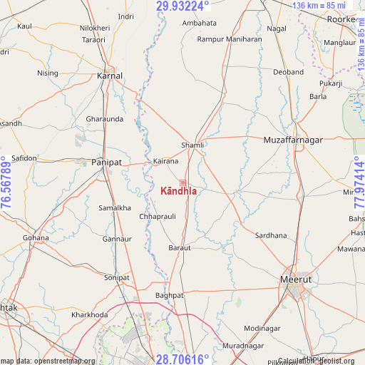
Kāndhla GPS coordinates[2]
29° 19' 15.744" North, 77° 16' 15.636" East
| Map corner | latitude | longitude |
|---|---|---|
| Upper-left | 29.93224°, | 76.56789° |
| Center: | 29.32104°, | 77.27101° |
| Lower-right: | 28.70616°, | 77.97414° |
| Map W x H: | 136.3×136.3 km | = 84.7×84.7mi |
| max Lat: | 34.9274° ⇑9.7% North |
| Kāndhla: | 29.32104° |
| min Lat: | ⇓90.3% South 8.09008° |
| min Long | Kāndhla | max Long |
| 68.82655° | 77.27101° | 96.81° |
| W 39.7%⇐ | ⇒60.3% E |
Elevation
Elevation of Kāndhla is 250 m = 820 ft, and this is 45.6 m = 150 ft below average elevation for this country.
| Max E: |
3681 m = 12077 ft | 40.1% |
| Avg. | 295.6 m = 970 ft | |
| Kāndhla | 250 m = 820 ft | |
Min E: |
1 m = 3 ft | 59.9% |
See also: Kāndhla elevation on elevation.city.
Geographical zone
Kāndhla is located in North temperate zone (between Tropic of Cancer and the Arctic Circle). Distance of this Northern Tropic circle is 654.3 km =406.6 mi to South.| Distance of | km | miles | from Kāndhla |
|---|---|---|---|
| North Pole | 6746.9 | 4192.3 | to North |
| Arctic Circle | 4141 | 2573.1 | to North |
| Tropic Cancer | 654.3 | 406.6 | to South |
| Equator | 3260.2 | 2025.8 | to South |


Nearby cities:
15 places around Kāndhla: (largest is in red/bold)
• Banat
17.8 km =11.1 mi,  27°
27°
• Baraut
24.4 km =15.2 mi,  181°
181°
• Budhāna
20.1 km =12.5 mi,  100°
100°
• Chhaprauli
15.5 km =9.6 mi,  217°
217°
• Garhi Pūkhta
25.7 km =16 mi,  8°
8°
• Jhinjhāna
22.7 km =14.1 mi,  348°
348°
• Kairāna
10.4 km =6.5 mi,  322°
322°
• Pānīpat
30.3 km =18.8 mi,  284°
284°
• Samālkha
26.8 km =16.7 mi,  249°
249°
• Shāhpur
27.4 km =17 mi,  83°
83°
• Shāmli
14.8 km =9.2 mi, 14°
• Sisauli
21.8 km =13.5 mi,  61°
61°
• Thāna Bhawan
32.7 km =20.3 mi, 25°
• Tīkri
13.1 km =8.1 mi,  141°
141°
• Ūn
29.4 km =18.3 mi,  357°
357°
Sources, notices
• [Note1] Compared only with cities in India existing in our database
• [Src1] Map data: © OpenStreetMap contributors (CC-BY-SA)
• [Src2] Other city data from geonames.org with taken over terms of usage.
• [Src3] Geographical zone / Annual Mean Temperature by Robert A. Rohde @ Wikipedia
