Banat geodata
Banat (Uttar Pradesh) is a populated place; located in India in Asia/Kolkata (GMT+5.5) time zone. With population of 21,580 people, there are 1928 cities with bigger population in this country. Compared to other cities in India, 91% of cities are located further ↓South; 58.9% of cities are located further →East and 59.3% of cities have lower elevation than Banat. Note1


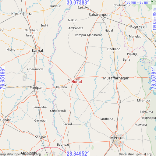
Banat GPS coordinates[2]
29° 27' 48.78" North, 77° 21' 17.208" East
| Map corner | latitude | longitude |
|---|---|---|
| Upper-left | 30.07388°, | 76.65166° |
| Center: | 29.46355°, | 77.35478° |
| Lower-right: | 28.84952°, | 78.05791° |
| Map W x H: | 136.1×136.1 km | = 84.6×84.6mi |
| max Lat: | 34.9274° ⇑9% North |
| Banat: | 29.46355° |
| min Lat: | ⇓91% South 8.09008° |
| min Long | Banat | max Long |
| 68.82655° | 77.35478° | 96.81° |
| W 41.1%⇐ | ⇒58.9% E |
Elevation
Elevation of Banat is 246 m = 807 ft, and this is 49.6 m = 163 ft below average elevation for this country.
| Max E: |
3681 m = 12077 ft | 40.7% |
| Avg. | 295.6 m = 970 ft | |
| Banat | 246 m = 807 ft | |
Min E: |
1 m = 3 ft | 59.3% |
See also: India elevation on elevation.city.
Geographical zone
Banat is located in North temperate zone (between Tropic of Cancer and the Arctic Circle). Distance of this Northern Tropic circle is 670.1 km =416.4 mi to South.| Distance of | km | miles | from Banat |
|---|---|---|---|
| North Pole | 6731 | 4182.4 | to North |
| Arctic Circle | 4125.1 | 2563.2 | to North |
| Tropic Cancer | 670.1 | 416.4 | to South |
| Equator | 3276 | 2035.6 | to South |


Nearby cities:
15 places around Banat: (largest is in red/bold)
• Budhāna
22.7 km =14.1 mi,  149°
149°
• Charthāwal
25 km =15.5 mi,  68°
68°
• Garhi Pūkhta
10.6 km =6.6 mi,  335°
335°
• Jalālābad
19.1 km =11.9 mi,  25°
25°
• Jhinjhāna
14.1 km =8.8 mi,  296°
296°
• Kairāna
16.3 km =10.1 mi,  242°
242°
• Kāndhla
17.8 km =11.1 mi,  207°
207°
• Nanauta
28.3 km =17.6 mi,  12°
12°
• Shāhpur
22.9 km =14.2 mi,  123°
123°
• Shāmli
4.6 km =2.9 mi,  250°
250°
• Sisauli
12.4 km =7.7 mi, 116°
• Thāna Bhawan
14.9 km =9.3 mi,  24°
24°
• Titron
23 km =14.3 mi,  352°
352°
• Tīkri
26.1 km =16.2 mi,  179°
179°
• Ūn
16.6 km =10.3 mi,  324°
324°
Sources, notices
• [Note1] Compared only with cities in India existing in our database
• [Src1] Map data: © OpenStreetMap contributors (CC-BY-SA)
• [Src2] Other city data from geonames.org with taken over terms of usage.
• [Src3] Geographical zone / Annual Mean Temperature by Robert A. Rohde @ Wikipedia
