Shāhpur geodata
Shāhpur (Uttar Pradesh) is a populated place; located in India in Asia/Kolkata (GMT+5.5) time zone. With population of 18,874 people, there are 2136 cities with bigger population in this country. Compared to other cities in India, 90.5% of cities are located further ↓South; 56.6% of cities are located further →East and 58.9% of cities have lower elevation than Shāhpur. Note1


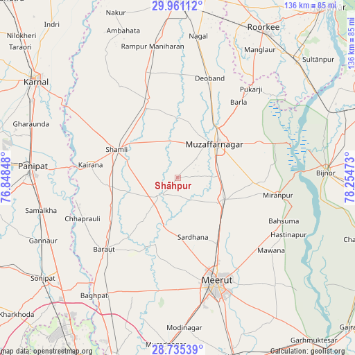
Shāhpur GPS coordinates[2]
29° 21' 0.36" North, 77° 33' 5.76" East
| Map corner | latitude | longitude |
|---|---|---|
| Upper-left | 29.96112°, | 76.84848° |
| Center: | 29.3501°, | 77.5516° |
| Lower-right: | 28.73539°, | 78.25473° |
| Map W x H: | 136.3×136.3 km | = 84.7×84.7mi |
| max Lat: | 34.9274° ⇑9.5% North |
| Shāhpur: | 29.3501° |
| min Lat: | ⇓90.5% South 8.09008° |
| min Long | Shāhpur | max Long |
| 68.82655° | 77.5516° | 96.81° |
| W 43.4%⇐ | ⇒56.6% E |
Elevation
Elevation of Shāhpur is 244 m = 801 ft, and this is 51.6 m = 169 ft below average elevation for this country.
| Max E: |
3681 m = 12077 ft | 41.1% |
| Avg. | 295.6 m = 970 ft | |
| Shāhpur | 244 m = 801 ft | |
Min E: |
1 m = 3 ft | 58.9% |
See also: India elevation on elevation.city.
Geographical zone
Shāhpur is located in North temperate zone (between Tropic of Cancer and the Arctic Circle). Distance of this Northern Tropic circle is 657.5 km =408.6 mi to South.| Distance of | km | miles | from Shāhpur |
|---|---|---|---|
| North Pole | 6743.6 | 4190.3 | to North |
| Arctic Circle | 4137.7 | 2571 | to North |
| Tropic Cancer | 657.5 | 408.6 | to South |
| Equator | 3263.4 | 2027.8 | to South |


Nearby cities:
15 places around Shāhpur: (largest is in red/bold)
• Banat
22.9 km =14.2 mi,  303°
303°
• Budhāna
10.1 km =6.3 mi,  226°
226°
• Charthāwal
22.3 km =13.9 mi,  10°
10°
• Daurāla
30.2 km =18.8 mi,  150°
150°
• Garhi Pūkhta
32.3 km =20.1 mi,  313°
313°
• Jalālābad
31.8 km =19.8 mi,  339°
339°
• Jānsath
29.1 km =18.1 mi,  95°
95°
• Khatauli
19.3 km =12 mi,  114°
114°
• Kāndhla
27.4 km =17 mi,  263°
263°
• Muzaffarnagar
19.9 km =12.4 mi,  47°
47°
• Sardhana
23.5 km =14.6 mi,  165°
165°
• Shāmli
25.9 km =16.1 mi, 295°
• Sisauli
10.7 km =6.6 mi, 311°
• Thāna Bhawan
29.2 km =18.1 mi,  333°
333°
• Tīkri
23.4 km =14.5 mi, 234°
Sources, notices
• [Note1] Compared only with cities in India existing in our database
• [Src1] Map data: © OpenStreetMap contributors (CC-BY-SA)
• [Src2] Other city data from geonames.org with taken over terms of usage.
• [Src3] Geographical zone / Annual Mean Temperature by Robert A. Rohde @ Wikipedia
