Pānīpat geodata
Pānīpat (Haryana) is a populated place; located in India in Asia/Kolkata (GMT+5.5) time zone. With population of 292,808 people, there are 152 cities with bigger population in this country. Compared to other cities in India, 90.6% of cities are located further ↓South; 63.4% of cities are located further →East and 56.5% of cities have lower elevation than Pānīpat. Note1


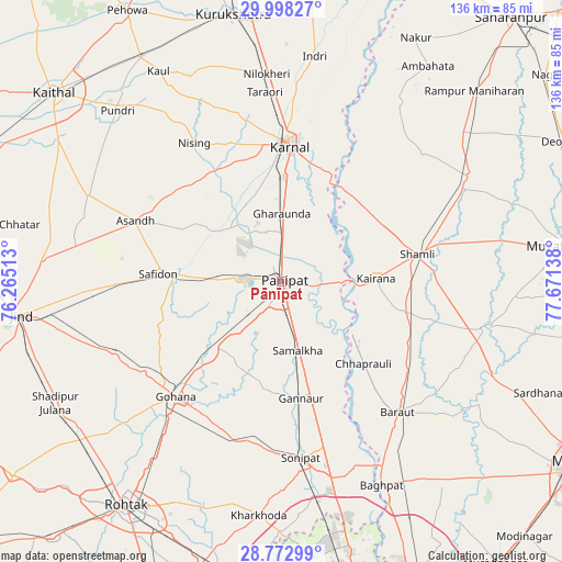
Pānīpat GPS coordinates[2]
29° 23' 14.892" North, 76° 58' 5.7" East
| Map corner | latitude | longitude |
|---|---|---|
| Upper-left | 29.99827°, | 76.26513° |
| Center: | 29.38747°, | 76.96825° |
| Lower-right: | 28.77299°, | 77.67138° |
| Map W x H: | 136.2×136.2 km | = 84.6×84.6mi |
| max Lat: | 34.9274° ⇑9.4% North |
| Pānīpat: | 29.38747° |
| min Lat: | ⇓90.6% South 8.09008° |
| min Long | Pānīpat | max Long |
| 68.82655° | 76.96825° | 96.81° |
| W 36.6%⇐ | ⇒63.4% E |
Elevation
Elevation of Pānīpat is 232 m = 761 ft, and this is 63.6 m = 209 ft below average elevation for this country.
| Max E: |
3681 m = 12077 ft | 43.5% |
| Avg. | 295.6 m = 970 ft | |
| Pānīpat | 232 m = 761 ft | |
Min E: |
1 m = 3 ft | 56.5% |
See also: Pānīpat elevation on elevation.city.
Geographical zone
Pānīpat is located in North temperate zone (between Tropic of Cancer and the Arctic Circle). Distance of this Northern Tropic circle is 661.7 km =411.2 mi to South.| Distance of | km | miles | from Pānīpat |
|---|---|---|---|
| North Pole | 6739.5 | 4187.7 | to North |
| Arctic Circle | 4133.6 | 2568.5 | to North |
| Tropic Cancer | 661.7 | 411.2 | to South |
| Equator | 3267.6 | 2030.4 | to South |


Nearby cities:
15 places around Pānīpat: (largest is in red/bold)
• Banat
38.4 km =23.9 mi,  77°
77°
• Chhaprauli
28.1 km =17.5 mi,  134°
134°
• Garhi Pūkhta
37.6 km =23.4 mi,  61°
61°
• Gharaunda
16.6 km =10.3 mi,  1°
1°
• Gohāna
37.9 km =23.5 mi,  222°
222°
• Jhinjhāna
28.9 km =18 mi, 59°
• Kairāna
23 km =14.3 mi,  87°
87°
• Karnāl
33.9 km =21.1 mi, 2°
• Kāndhla
30.3 km =18.8 mi,  104°
104°
• Safidon
28.9 km =18 mi,  274°
274°
• Samālkha
17.4 km =10.8 mi,  165°
165°
• Shāmli
33.8 km =21 mi, 78°
• Tīkri
41.4 km =25.7 mi,  115°
115°
• Āsandh
38.1 km =23.7 mi,  292°
292°
• Ūn
35.4 km =22 mi,  51°
51°
Sources, notices
• [Note1] Compared only with cities in India existing in our database
• [Src1] Map data: © OpenStreetMap contributors (CC-BY-SA)
• [Src2] Other city data from geonames.org with taken over terms of usage.
• [Src3] Geographical zone / Annual Mean Temperature by Robert A. Rohde @ Wikipedia
