Garhi Pūkhta geodata
Garhi Pūkhta (Uttar Pradesh) is a populated place; located in India in Asia/Kolkata (GMT+5.5) time zone. With population of 13,381 people, there are 2620 cities with bigger population in this country. Compared to other cities in India, 91.4% of cities are located further ↓South; 59.7% of cities are located further →East and 60.2% of cities have lower elevation than Garhi Pūkhta. Note1


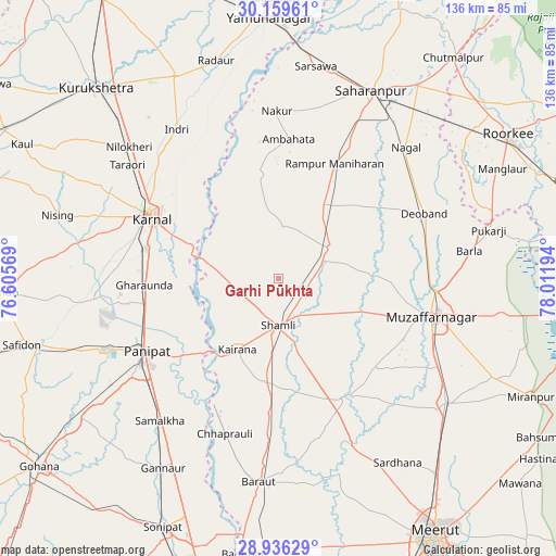
Garhi Pūkhta GPS coordinates[2]
29° 32' 59.28" North, 77° 18' 31.716" East
| Map corner | latitude | longitude |
|---|---|---|
| Upper-left | 30.15961°, | 76.60569° |
| Center: | 29.5498°, | 77.30881° |
| Lower-right: | 28.93629°, | 78.01194° |
| Map W x H: | 136×136 km | = 84.5×84.5mi |
| max Lat: | 34.9274° ⇑8.6% North |
| Garhi Pūkhta: | 29.5498° |
| min Lat: | ⇓91.4% South 8.09008° |
| min Long | Garhi Pūkhta | max Long |
| 68.82655° | 77.30881° | 96.81° |
| W 40.3%⇐ | ⇒59.7% E |
Elevation
Elevation of Garhi Pūkhta is 252 m = 827 ft, and this is 43.6 m = 143 ft below average elevation for this country.
| Max E: |
3681 m = 12077 ft | 39.8% |
| Avg. | 295.6 m = 970 ft | |
| Garhi Pūkhta | 252 m = 827 ft | |
Min E: |
1 m = 3 ft | 60.2% |
See also: India elevation on elevation.city.
Geographical zone
Garhi Pūkhta is located in North temperate zone (between Tropic of Cancer and the Arctic Circle). Distance of this Northern Tropic circle is 679.7 km =422.3 mi to South.| Distance of | km | miles | from Garhi Pūkhta |
|---|---|---|---|
| North Pole | 6721.4 | 4176.5 | to North |
| Arctic Circle | 4115.5 | 2557.3 | to North |
| Tropic Cancer | 679.7 | 422.3 | to South |
| Equator | 3285.6 | 2041.6 | to South |


Nearby cities:
15 places around Garhi Pūkhta: (largest is in red/bold)
• Banat
10.6 km =6.6 mi,  155°
155°
• Charthāwal
27.6 km =17.1 mi,  90°
90°
• Gangoh
26 km =16.2 mi,  350°
350°
• Jalālābad
14.7 km =9.1 mi,  58°
58°
• Jhinjhāna
8.7 km =5.4 mi,  248°
248°
• Kairāna
19.9 km =12.4 mi,  210°
210°
• Kāndhla
25.7 km =16 mi,  188°
188°
• Nanauta
20.9 km =13 mi,  30°
30°
• Rāmpur
31.7 km =19.7 mi, 25°
• Shāhpur
32.3 km =20.1 mi,  133°
133°
• Shāmli
11.1 km =6.9 mi,  179°
179°
• Sisauli
21.6 km =13.4 mi, 134°
• Thāna Bhawan
11.3 km =7 mi,  69°
69°
• Titron
13.2 km =8.2 mi,  6°
6°
• Ūn
6.5 km =4 mi,  306°
306°
Sources, notices
• [Note1] Compared only with cities in India existing in our database
• [Src1] Map data: © OpenStreetMap contributors (CC-BY-SA)
• [Src2] Other city data from geonames.org with taken over terms of usage.
• [Src3] Geographical zone / Annual Mean Temperature by Robert A. Rohde @ Wikipedia
