Būndu geodata
Būndu (Jharkhand) is a populated place; located in India in Asia/Kolkata (GMT+5.5) time zone. With population of 19,467 people, there are 2076 cities with bigger population in this country. Compared to other cities in India, 52.6% of cities are located further ↓South; 85.8% of cities are located further ←West and 69.7% of cities have lower elevation than Būndu. Note1


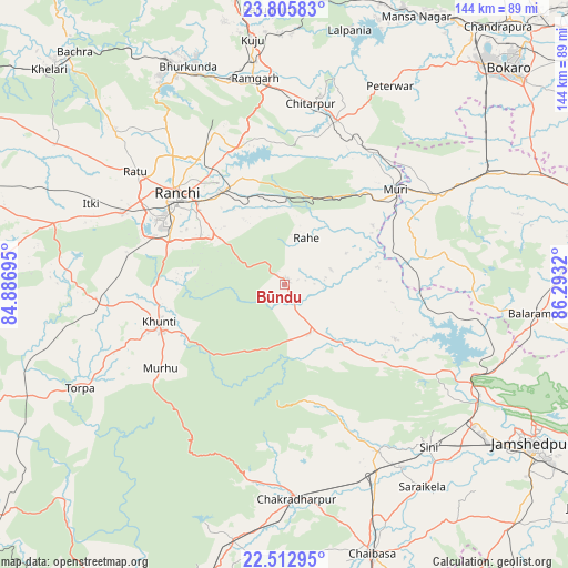
Būndu GPS coordinates[2]
23° 9' 39.42" North, 85° 35' 24.252" East
| Map corner | latitude | longitude |
|---|---|---|
| Upper-left | 23.80583°, | 84.88695° |
| Center: | 23.16095°, | 85.59007° |
| Lower-right: | 22.51295°, | 86.2932° |
| Map W x H: | 143.8×143.8 km | = 89.4×89.4mi |
| max Lat: | 34.9274° ⇑47.4% North |
| Būndu: | 23.16095° |
| min Lat: | ⇓52.6% South 8.09008° |
| min Long | Būndu | max Long |
| 68.82655° | 85.59007° | 96.81° |
| W 85.8%⇐ | ⇒14.2% E |
Elevation
Elevation of Būndu is 325 m = 1066 ft, and this is 29.4 m = 96 ft above average elevation for this country.
| Max E: |
3681 m = 12077 ft | 30.3% |
| Būndu | 325 m 1066 ft | |
| Avg. | 295.6 m = 970 ft | |
Min E: |
1 m = 3 ft | 69.7% |
See also: India elevation on elevation.city.
Geographical zone
Būndu is located in North Torrid zone (between Equator and Tropic of Cancer). Distance of this Northern Tropic circle is 30.7 km =19.1 mi to North.| Distance of | km | miles | from Būndu |
|---|---|---|---|
| North Pole | 7431.8 | 4617.9 | to North |
| Arctic Circle | 4825.9 | 2998.7 | to North |
| Tropic Cancer | 30.7 | 19.1 | to North |
| Equator | 2575.3 | 1600.2 | to South |


Nearby cities:
15 places around Būndu: (largest is in red/bold)
• Balarāmpur
65.1 km =40.5 mi,  96°
96°
• Barkā Kānā
52.7 km =32.7 mi,  346°
346°
• Chakradharpur
54.1 km =33.6 mi,  175°
175°
• Chāndil
52.5 km =32.6 mi,  115°
115°
• Jhalidā
45.5 km =28.3 mi,  60°
60°
• Kharsāwān
48 km =29.8 mi,  149°
149°
• Khunti
33.3 km =20.7 mi,  253°
253°
• Kuju
63.3 km =39.3 mi, 352°
• Kāndra
58.5 km =36.4 mi,  126°
126°
• Kānke
41 km =25.5 mi,  317°
317°
• Muri
36.3 km =22.6 mi,  50°
50°
• Ranchi
35.1 km =21.8 mi,  305°
305°
• Rāmgarh
52.7 km =32.7 mi, 352°
• Saraikela
62.1 km =38.6 mi, 145°
• Sini
54.7 km =34 mi,  138°
138°
Sources, notices
• [Note1] Compared only with cities in India existing in our database
• [Src1] Map data: © OpenStreetMap contributors (CC-BY-SA)
• [Src2] Other city data from geonames.org with taken over terms of usage.
• [Src3] Geographical zone / Annual Mean Temperature by Robert A. Rohde @ Wikipedia
