Muri geodata
Muri (West Bengal) is a populated place; located in India in Asia/Kolkata (GMT+5.5) time zone. With population of 12,656 people, there are 2687 cities with bigger population in this country. Compared to other cities in India, 54.1% of cities are located further ↓South; 86.6% of cities are located further ←West and 61.5% of cities have lower elevation than Muri. Note1


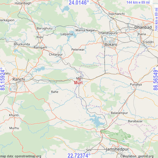
Muri GPS coordinates[2]
23° 22' 14.664" North, 85° 51' 44.496" East
| Map corner | latitude | longitude |
|---|---|---|
| Upper-left | 24.0146°, | 85.15924° |
| Center: | 23.37074°, | 85.86236° |
| Lower-right: | 22.72374°, | 86.56549° |
| Map W x H: | 143.5×143.5 km | = 89.2×89.2mi |
| max Lat: | 34.9274° ⇑45.9% North |
| Muri: | 23.37074° |
| min Lat: | ⇓54.1% South 8.09008° |
| min Long | Muri | max Long |
| 68.82655° | 85.86236° | 96.81° |
| W 86.6%⇐ | ⇒13.4% E |
Elevation
Elevation of Muri is 262 m = 860 ft, and this is 33.6 m = 110 ft below average elevation for this country.
| Max E: |
3681 m = 12077 ft | 38.5% |
| Avg. | 295.6 m = 970 ft | |
| Muri | 262 m = 860 ft | |
Min E: |
1 m = 3 ft | 61.5% |
See also: India elevation on elevation.city.
Geographical zone
Muri is located in North Torrid zone (between Equator and Tropic of Cancer). Distance of this Northern Tropic circle is 7.3 km =4.5 mi to North.| Distance of | km | miles | from Muri |
|---|---|---|---|
| North Pole | 7408.5 | 4603.4 | to North |
| Arctic Circle | 4802.6 | 2984.2 | to North |
| Tropic Cancer | 7.3 | 4.5 | to North |
| Equator | 2598.6 | 1614.7 | to South |


Nearby cities:
15 places around Muri: (largest is in red/bold)
• Balarāmpur
47.8 km =29.7 mi,  129°
129°
• Barkā Kānā
49 km =30.4 mi,  304°
304°
• Bokāro
47.3 km =29.4 mi,  11°
11°
• Būndu
36.3 km =22.6 mi,  230°
230°
• Chāndil
49.9 km =31 mi,  156°
156°
• Chās
42.8 km =26.6 mi,  46°
46°
• Dugda
52.2 km =32.4 mi,  37°
37°
• Gumia
47.6 km =29.6 mi,  355°
355°
• Jhalidā
11.7 km =7.3 mi,  92°
92°
• Kuju
53.3 km =33.1 mi,  317°
317°
• Kānke
55.7 km =34.6 mi,  277°
277°
• Puruliya
51.3 km =31.9 mi, 94°
• Ranchi
56.5 km =35.1 mi,  266°
266°
• Rāmgarh
45.2 km =28.1 mi,  309°
309°
• Sāruberā
51.6 km =32.1 mi,  15°
15°
Sources, notices
• [Note1] Compared only with cities in India existing in our database
• [Src1] Map data: © OpenStreetMap contributors (CC-BY-SA)
• [Src2] Other city data from geonames.org with taken over terms of usage.
• [Src3] Geographical zone / Annual Mean Temperature by Robert A. Rohde @ Wikipedia
